Well, it is now two weeks before I start my hike on the John Muir Trail and I’ve still done little in terms of my physical conditioning. I say that, but I’m actually getting heavier by the day, so perhaps my physical conditioning is making some progress, albeit it in the wrong direction.
Despite that little planning wrinkle, I’m paying close attention to building my kit to reflect the difference between the Appalachian Trail and the JMT. I bought a sheet of Tyvek. This is normally used to wrap and protect houses as they are being built. I’ll be using mine as a ground sheet under my tent. On the A.T. I pitched my tent directly on the ground, causing a few punctures that have now been repaired. The Tyvek sheet will help keep me dry from below and it is hardy enough to minimize those punctures.
I also had to buy a bear canister. These are mandatory on the JMT for, I presume, fairly obvious reasons. The days of hanging my food bag in a tree are over. The box that the canister arrived in had spooky-looking pictures of confused bears trying to find their way into the canister. The lid of this one doubles as a cookpot, so that saves me some additional weight.
I was intending to buy a waterproof and shockproof case for my phone after the debacle of my iPhone on the A.T. However, the cost of $80 seemed a little excessive so I passed. Literally less than an hour later, I saw the case offered by Groupon for half price, so that has now been added to my kit. I’m guessing that Facebook “saw” what I was looking for online and provided me with the means to buy it cheaper. This may be a little bit too much Big Brother for most people but, if it saves me $40, then happy days.
One major plus has been a loaned gadget from a friend. This is a Spot Gen3, which will ease Diane’s mind about where exactly her husband is every night.
The device is a GPS tracker that plots a precise location through satellites. Every night, as I reach camp, I will turn on the tracker and, once it syncs with a satellite, it will send an email with a pre-written message. This says something like, “Going well, missing you. xxxx” The email will also contain my co-ordinates and Diane will be able to link to a map that shows exactly where I am. I’ll probably send one in the morning as well, if only to prove that I survived the night. Then there is a custom message that says “Delayed a little, we’re fine. Xxxx” Finally, the last message is “Had a few problems, nothing to worry about. I’ll tell you about it when I can get to a phone. Xxxx” As you’d imagine, if I pressed the button for that one, Diane would come out to California and track me down. I can almost guarantee that I won’t be pressing that button. Last, there is an alarm button that sends my location to the emergency services. Let’s hope that doesn’t happen either, though I’d be more inclined to press that one than the previous one.
There is apparently quite a bit of snow through the high passes on the John Muir Trail this year, so I took the extra precaution of getting some snow chains for my boots. They are a bit like the snow chains you fit to your car, giving the necessary traction I’ll need to get through those passes.
Some of the clothes I used on the A.T. are adequate for this hike—apart from the slightly musty odor—so I didn’t need to buy too much else, other than a pair of hiking pants and a couple of pairs of wicking underpants. I’ll be using my two Family Partnership Center shirts from our 5K runs, so the blue theme will continue as I reassume the mantle of Mighty Blue. That transition will take place in a week or so, as I choose between the shiny bald look or the less scary buzz cut. I think I’ll start with the buzz cut to see how that looks before finally committing myself.
It hardly seems possible to me, but my next adventure is really just around the corner. On July 5, I’ll be flying to Reno, then taking a bus to Mammoth Lakes, where I will be meeting my team: Lighterknot, Tee Bird, and her husband, Joe. Tee Bird and Joe have hiked several times in the recent past, while Lighterknot and his lovely wife, Deb, are soon heading for Ireland to do some warm-up hiking.
Me? I walked around our neighbourhood yesterday and totally knackered myself. This was a similar outcome to an earlier hike, of about six miles, which I did in early May. I have put on a fair chunk of weight since I returned from the A.T., so I imagine that may have had something to do with those less than stellar performances. However, I feel fine this morning, which is an improvement on my six miler, when I took about 48 hours to shake the aching from my legs. It is extraordinary how out of shape you can become when you sit on your backside and write for a year.
I’m not terribly worried about the legs, as they will get better the more I walk. My bigger concern for the John Muir Trail is the altitude at which we’ll be hanging out. We start at about 8,500 feet and climb to over 10,000 feet in the first day or so. Over the three or four weeks we’ll be dropping down to about 4,000 feet, but will spend a fair chunk of time over 10,000 feet, finishing on the top of Mount Whitney—the highest point in the lower 48 states—before hiking another 30 miles to find a road. I’m not one for taking too much medication (something of a rarity over here), but I have asked my doctor to prescribe me some altitude sickness pills for the trip. I’ll start taking them when I get to Mammoth Lakes and that should stave off the worst effects.
That additional 30 miles at the end, by the way, is because we have been unable to get hold of a permit to exit through Whitney Portal. This adds two or three days to the end of the hike but by that time we should all be hiking like pack horses.
I’ve been looking at my kit and hope that it will all suffice for one more hike. My tent has been repaired and I know that my backpack needs some attention. The sleeping quilt and pad seem to have retained the rather interesting smell with which they returned, so they need a little bit of TLC as well. These are just teething troubles and will all be sorted out before I set off.
One last thing for the time being. Mighty Blue will be returning in all his (my) bald glory. I’ll be getting my friend Wendell to shave me within an inch of my life and, basically, shine me up ready for the big day. Looking at the previous pictures, that may be ill-advised, yet I know that the haircut will get me back in the mood to go at it.
My long drawn-out process of writing, editing, proofing, and publishing my books is now complete. The Kindle and Kobo versions were published in the first few days of May, but the printed versions took a little longer. This afternoon, I hit the button on Createspace to approve my “proof” books. This made them available on the Createspace site and set up the countdown to have them available on Amazon. Apparently, this should take 3-5 business days.
If you decide to buy one, or both, of my books, you’ll be finding out a lot more about me than you may wish to know. As a consequence, please accept my apologies in advance for the few profanities that I felt constrained to retain, as well as the unavoidable references to feral living that occur from time to time. When you live in the woods—on and off—for six months, you tend towards the basics of living as opposed to the fripperies.
Having resolved never to hike again, I am naturally planning another hike, in July, on the John Muir Trail. I will be recording the journey and plan to write and publish the story of this hike when I return. In the interim, however, I am finishing a third Appalachian Trail book, Hiking the Appalachian Trail is Easy: Especially When You’ve Never Hiked Before. This one will be FREE and available as a Kindle book. If you’d like a copy, please click here and sign up for my email list. When the book is ready, you’ll be the first to know.
It has been a while since I posted, although I’ve not been slacking. I’ve been working away at finishing my book. I’m currently on the third edit with my editor and have made a few decisions. The first is that I am going to publish this story of my hike in two books. After all, it was a long walk, so it was bound to be a long book. Second, the books are still going to be called My Appalachian Trial, but they will have different taglines to identify each one. My son was particularly inventive with the first volume and has given me “Creaking Geezer, Hidden Flagon.” This reflects my less-than-youthful status and my former predilection to excessive drinking and generally bad behavior. I’m still thinking about the second one, so all ideas will be warmly received. With a bit of luck, it will share some of the themes of change, redemption, loneliness and a hopeful future.
The covers for these two books are currently being worked upon, so I hope that they similarly reflect those themes. I’ve had to give a lot of thought to marketing the book and have been overloaded with ideas through various courses and YouTube advice videos. I’m charting that course with an eye towards value for money but maximum penetration of my target audience. If I have your email address, I’m afraid you will get an initial email from me. Feel free to let me know if you want me to remove your address from my email list and I will make sure that you don’t get bothered again.
Editing has been a revelation. I never knew the differences between English and American English, yet I have swallowed my pride and gone along for the ride. I also didn’t realize how long my sentences were and how many times I wrote “indeed” and “rather.” When I was doing the digital version of scribbling away, I rarely stopped to correct myself and have found so many mistakes. At the moment, I’m hoping for publication in early April, with the book available on Kindle, Kobo, iBooks and Nook. There will also be a print version for those who prefer to hold a book in their hands. One of the exciting features of ebooks is the ability to enlarge pictures as they appear. This is especially good with the maps I have added and allows the reader to zoom into the maps and see the topography and follow the path along with the book.
Having said that I would never hike again after my little adventure, I have yielded to the temptation and will be tackling the John Muir Trail in July this year. I’m going with two of my hiking buddies, Lighterknot and Tee Bird, along with Tee Bird’s husband, Joe. The blog for that will be starting soon, once I can sort a few things out. I’ll be 64 in October this year, so I’m naming it “When I’m 64.” I’m also developing a new website that I hope will be up and running within the month.
I’ve been using some of the pictures and videos that I took on the Appalachian Trail to produce three short films that you may enjoy. Click on any of the links below, though they are sorted chronologically. You’ll see an improvement in my technique as I got used to using the software. I hope you enjoy them.
This has been a remarkable period of my life, for which I will always be grateful. Hiking the Appalachian Trail proved to be life-changing for me in so many ways. Depending upon the success or otherwise of my book(s), I hope to write more, with a John Muir Trail hike and a novel in the works.
Lastly, thanks for following my journey. I now know that there are more adventures to come, so I hope you are able to share my next steps, either through my blog or subsequent books. Thanks for being along with me on the ride.
A year ago, I was just a couple of weeks away from finishing my adventure in the woods and was plodding confidently through Maine with my new pals. This turned out to be an experience which has forever changed me, in ways I still can’t adequately quantify. However, for the past 6 months, I’ve been trying to put the adventure into words, incorporating not only my posts, but also my back story to try and define what this meant to me and how, and why, I did it.
The reason for this post is to mark something of a milestone, as I have just written my 100,000th word. To me, this is a staggeringly high number, as I was concerned at the outset that I wouldn’t be able to write even 50,000 words, yet I find I have so much more to say than I would ever have imagined. Re-reading my posts and watching my videos and pictures once more, I have seen everything with new eyes, often glimpsing people in the videos and pictures I wouldn’t actually meet for another couple of hundred miles, as well as noticing quite how often I recorded my loneliness.
I should also let you know that these 100,000 words have taken me to a point in Pennsylvania that still leaves me about 1,000 miles to hike.
Now back home and recovered from the physical aspects of the hike, I find that recording my story has taken on a new dimension, yet it ressembles the hike in its loneliness and mental demands.
I learned that the AT can be interpreted as a metaphor for life, in that you have to face what the trail, or your day, has in store for you and get through your day as best you can and back to your home (my tent) at night. During the day, there will be ups and downs and the odd level path, yet it constantly throws something new at you and your only response can be to face it and overcome it. I fell constantly, as I have in life, yet there was never an alternative to getting up again, dusting myself off, repairing cuts and bruises and moving forward.
Writing this has been a painful self-examination and I still have no idea if it is any good, yet it has been cathartic for me to do. The loneliness pervades my writing yet the end stays in my sight. I know that I was able to get that iconic picture on the top of Katahdin as I exalted in my triumph at completing the trail. I just hope that the last word in this book feels just as good.
It’s been four months since I tasted my version of victory at the top of Mt Katahdin and I’m following up with a brief post to let you know how different the post-hike time has been.
I’ve put on some of the weight I lost, my Peanut Butter obsession returning from time to time. I also retain many of the aches and pains that built up over that six month period and have been cycling and walking to try and relieve them.
By far the biggest and most surprising difference in me, though, is that my focus seems to have deserted me. I’ve hardly been able to read a newspaper article without getting distracted after a few seconds and I’m only now beginning to get some of that focus back. I was truly expecting to be back to normal in a few days, a week at tops, yet I don’t think I’ll ever be back to “normal,” whatever that even meant.
I believe that I’ve become less judgmental and more empathetic and I hope that I haven’t loss the essence of who I was before, yet I find myself constantly trying to define what the Appalachian Trail meant to me and how it has impacted me.
Diane has been wonderful, giving me both the time and space I’ve needed to come down from the highs (literally) that I experienced, as well as feeding me relentlessly in the typical Puerto Rican way, cooking sufficient food in case 20 people turn up out of the blue. She was my rock when I was away and remains the absolute center of my life now that I’m back.
I went for a 5.75 mile walk this morning, just around my own and a neighboring community, and I was struck by the solitary nature of walking in a way I never noticed prior to my hike. For part of this morning’s walk I was alongside US301, a busy road, yet I was in my own bubble and within my own thoughts. The AT taught me to be more independent and happier in my own company. I always suspected that I’d be comfortable with that before the hike, but it was confirmed both on the hike and on my return, when I revisited my blog and my videos to see how comfortable I’d become with myself and my surroundings. If nothing else, this was a valuable realization.
Another valuable realization from this morning was how difficult walking over 2,000 miles can be. My legs are aching after just 5.75 miles on flat ground, with no roots or rocks, nor pesky mountains in the way. The fact that I completed the Trail is a wonder to me still, a wonder I hope I never lose.
I’ve started my book on the Trail and, 5,000 words into it, I still haven’t taken a single step, as I’ve been recording my preparations, yet I’m already reliving the moments, the people, the challenges and the delights and relishing sharing a far fuller story than I could ever record on this blog. I’ll try to update my progress with the book on this blog from time to time and, should any of you be interested, send me an email under the contact section of this site and I’ll let you know when it is finished.
Sunday September 21- Monday September 29 @ 10.35am ET, Maine 15, Monson, ME – The summit of Mt Katahdin (Mile 2185.3 miles since Springer Mountain and zero miles to Katahdin)
This post has taken a while to get to get round to, as it has taken me a couple of days to get to grips with my own return to reality, so I apologize for the delay. If you have followed the Facebook page, then you’ll have seen the picture on top of Katahdin and, looking at it now, I can see the relief in my face. While I knew that I wanted this to be over, I hadn’t expected my visceral reaction at the culmination of this adventure, yet it was no less intense than it looks.
The week began just before the 100 Mile Wilderness, which is neither precisely 100 miles, nor a wilderness. There is a rather dramatic sign that warns hikers to prepare to carry 10 days of food as there is no way to resupply through the wilderness, yet things have moved on since that was truly applicable.
Our team, (me, Lighterknot, Tee Bird and Trillium) had determined that it was not only easy to resupply, but it was also easy to be picked up at regular intervals and brought back into Monson for a meal in the local pub and a bed in Shaw’s Hostel. We found a terrific local guy, Buddy, to assist us in this plan, which basically went like this.
The first day, Sunday, Buddy drove us out to Long Pond Stream, which was, in Trail miles, about 14.5 miles NORTH of Monson and we were to head back southwards straight to Monson. This meant that we had an immediate ford to negotiate and, somewhat inevitably, I was the only one who didn’t quite make it, managing to dunk my boot into the stream, with a resulting “squelch” for the rest of the day. However, once that little accident had passed, we had a fairly uneventful day going the “wrong” way, with the expected rain not materializing as strongly as the forecast had indicated. I did take one or two terrific snaps and, as this is my last post, I’m going to indulge myself and add a few of them here.
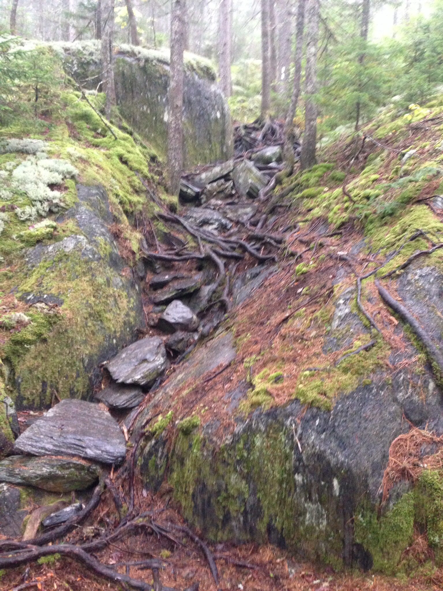
I know I’ve always talked about the difficulty of the roots and rocks, but this shows what I’m talking about, particularly when both have had either rain or dew upon them. In this case, the steady, though light, rain made them especially tricky.
I’ve also showed the wonderful things that light can do to the forest, particularly in the early morning, so these are another couple of little gems that demonstrate this. I really couldn’t get enough of these moments on the trail.
Having done the first 15 or so miles of the Wilderness, Buddy returned to the same spot the following day and pointed us north, giving us another, slightly longer day that would end at Katahdin Iron Works Road.
It was a terrific day spoiled by one silly slip on my part. The rain had continued through the night, but it was expected to blow through after about 9am and, indeed, the weather abated after about 8.30, with the rain giving way to sun, though it remained breezy throughout the day. We knew that it was going to be a day of ups and downs, with plenty of opportunities to keep warm as we pushed uphill. There were some spectacular lake, or pond, views that continued to wow us and we were all really enjoying the early part of the hike, with the view from Barren Ledges on Barren Mountain being particularly spectacular.
We had had a cold night a few nights before and started to notice the changing colors of the foliage, with this shot from Third Mountain being the first evidence of that iconic time of year. This would intensify as the week went on.
This day, though tough because of the more rugged profile of the hike, was great preparation for our legs, and we all really enjoyed the comparative severity of the day in contrast to the day before. I had just been speaking with another thru-hiker and my team had hiked on, when I slipped on a wet log that was lying in my path and flipped dramatically in the air for my 45th and what turned out to be my most dramatic fall of the trip. As I came down, in that slow motion way that we sometimes experience, I was aware of a rock to my left and flinched at a potential collision between skull and rock. Happily for me, my head missed the rock, but I ended up wedged, literally, between a rock and a hard place, in this case, the log.
It was excruciatingly painful and I knew that I had impacted my phone in my left pocket. This actually bent the phone and gave me a bruise for my troubles. There was considerable blood coming from both arms and, once I had been pulled to my feet, I was relieved that nothing was broken, other than my phone of course.
In what has been something of a hallmark of the trip, I had no real alternative other than to carry on and did exactly that, wincing from time to time, though relieved that I was not only not dead, but also able to walk. Astonishingly, my phone, though terminally bent, continued to operate as a phone.
Buddy had judged our woefully slow walking pace and was there to meet us as we emerged, tired from going over 5 mountains but happy to have wiped out another 15 miles of the wilderness. The ride back to Monson was an hour this time, with another opportunity to fill up on calories once more.
Back in the woods the following morning, with my left leg aching sporadically, we had another 15 miler that took us over the last high mountain before Katahdin, White Cap Mountain. Another great view and a self-indulgent selfie followed, this time without my trusty stic-pic to extend the view, as the case had shattered in my fall the previous day.
This time, we emerged at West Branch Ponds Road, a full two hour drive from Monson, including an 18 mile bumpety bump along a dirt road used by logging trucks. This drive had to be repeated the following day, with our last slackpack with Buddy, as he was staying in the area for a bit of fishing before meeting us once more, this time at Jo-Mary Road, to load us up with our full packs for the last time. In this way, we got through the more mountainous part of the wilderness and preserved our knees for our impending assault on Katahdin, which means “the greatest mountain.” On the way to meet Buddy for the last time, we were lucky enough to stop by the deliciously calm Crawford Pond and shoot the developing colors of the foliage.
Getting to grips with our full packs once more at the end of another satisfying day, we tried to find a campsite in the woods, as the light was beginning to fade. Luckily, I spotted an opening up of the path and found a spot for a couple of tents for me and Lighterknot, while the women moved deeper into the forest to set up about 50 yards from us. Once more, it was great to be back in the woods and I sat on a log and prepared my pasta, with only the twittering nuthatches as company; it was gloriously calming.
Looking at our maps, we headed for Nahmakanta Lake Campsite, another 15 miles north, yet were rewarded once more on the way with another gorgeous lake, Pemadumcook, for an awe-inspiring view of our ultimate goal.
Believe me, as the four of us were joined by another few hikers, this view quietened us all down as the reality of our imminent success dawned upon us. The fact that our target seemed to be increasing in size as we got closer made us all focus on the job ahead and, once sated with the magnificent view, we sped on to Nahmakanta Lake.
I absolutely LOVED Nahmakanta Lake. We got there earlier than usual and, having set up camp, hung out on the stones beside the lake and enjoyed the afternoon sun as it dropped slowly out of sight to the west. I was mesmerized by the peace of the place and sat for over an hour on a rock thinking about my time on the Trail and my hopes for my return to Diane. I shot this video and, thankfully for you, resisted filming much more! Maine has proved to be the most beautiful state and, in conjunction with New Hampshire, the last two states have been the highlights of the trip for me.
We were lucky enough to find almost as great a spot the following day, setting up at Rainbow Spring Campsite, after a fairly flat profile that allowed us to enjoy the day and not wear us out. Earlier in the day, as we were leaving Nahmakanta, the path took us out of the woods for about 200 yards and led us along the beach around the lake for that short distance. Of course, I recorded this unexpected treat before we dived back into the woods.
Sadly, I wasn’t able to grab my camera in time to record two moose that suddenly emerged from the bushes about 25 yards ahead of us. There was a mother and her calf (apparently from the bovine family), and we watched open-mouthed as they sauntered back into the woods to continue their assault on the limitless leaves. I may have said it before, but seeing the majesty of such animals in their own, very comfortable environment is very humbling and reduces mankind to awestruck onlookers.
No apologies for showing that evening’s campsite attraction, where about a dozen hikers, mainly thru-bikers but also some section hikers, gathered to watch the sun go down. The following morning, I got there early, by myself, and filmed as the sun pulled itself up to light up the trees on the opposite bank. I’ve been really appreciating my time alone and marveling at the glorious displays that nature is granting me.
It was now Saturday and everybody was feeling the growing anticipation of Monday’s climb, appreciating the beauty of the past few weeks, yet ready to go home and keenly aware that Monday was forecast to let us down with a 50% chance of rain, having rewarded us with stunning weather all week with both Saturday and Sunday expected to continue in this vein.
The walk out of the wilderness, to the deeply unattractive Abol
Bridge, was easy and mainly flat, with a wonderful little trip over Rainbow Ledges that gave us another glorious shot of our goal though, amusingly, Tee Bird and I spent about 10 minutes trying to identify Katahdin, only to find a few minutes later that we had been looking in precisely the wrong direction. The real thing, as you can see in this picture, wasn’t to be misidentified.
I’m not sure if it was the anticipation of the finish, or the accumulative effect of my 45 falls, but I was really struggling on what should have been an easy day and, when I mentioned this to Lighterknot, he felt exactly the same, so we presumed it to be the former.
The only real attraction to Abol Bridge is the fact that there is a campsite and restaurant, where Lighterknot and I demolished burgers for both lunch and dinner. However, the view from the bridge itself was pretty darn wonderful, as you can see.
I left it a little too late to take advantage of the shower that evening, so hurried into it at 5.30 the following morning. Unfortunately, I was completely unable to make my chosen shower work, so gathered up my clothes and darted across the room to the other shower before failing miserably with that one as well. As a consequence, my trip up Katahdin was going to take place with the added weight of a week’s worth of accumulated sweat and grime and a shirt commensurately filthy. Nice.
The traditional camping spot for the night before the climb is only 10 miles from Abol Bridge, in Baxter State Park at the Katahdin Stream Campground so, with only a flat 10 miles to go, we took our time and even detoured to yet another pond, Daicey Pond and yet another stupendous view, this time while sitting on a rocking chair.
On arrival at the campground, there was a palpable excitement around us, as hikers were on their way down from that day’s ascent and we greeted them as enthusiastically as heroes returning from combat. By now, we all had a huge mutual respect for one another and were delighted to see our fellow hikers achieving what we were hoping to achieve in 24 hours time.
Trillium’s partner, Jon, had booked a lean to for the two of them and, as Lighterknot had been met by his wife Deb and his mom, Mama Jean, they were going into Millinocket for the evening. Trillium and Jon let Tee Bird and me pitch our tents outside the lean to and we were in a great spot to greet and talk with the hikers as they returned with their stories of the day’s climb. Unfortunately, just as dusk was upon us, a ranger came by and told us that we weren’t allowed to camp there (even though we were in nobody’s way) and that we had to move about 20 yards further down. For that privilege, we were also charged $15 each. Despite getting particularly British on him, he wasn’t to be moved, so I had to accept the inevitable and drag my already erected tent to a new spot. I wasn’t happy.
Earlier, the same ranger had taken my registration to climb the mountain and recorded me as the 699th successful thru-hiker of the year (this appeared to be a little premature to me). Apparently. between 3,000 and 4,000 had started in Georgia, though numbers aren’t yet finalized.
That night, I was unable to sleep too much and actually sat up in my tent to contemplate what I was about to achieve. Funnily enough, one of the things that mattered to me most in those moments was the fact that my son, Rob, was going to accept my trail name, Mighty Blue, having insisted, not unreasonably, that I couldn’t claim to be mighty before I’d taken a step. However, he had already started calling me”Almost Mighty Blue” for a couple of weeks, so I knew that I was on the right track.
I also thought of what I was going to do when I returned to Florida and had the luxurious feeling of not knowing and being entirely open to anything that might come my way. That is a surprisingly attractive feeling to have.
Above all, of course, I was relishing my return to Diane and getting on with our lives. Stepping outside of your marriage, albeit with your partner’s blessing and support, is a strange thing to happen in a happy marriage and I will always be grateful for her buy-in to my adventure.
In the morning, Trillium and Jon headed out at 6.20, while Tee Bird and I left with Lighterknot at 6.50.
The going was easy for a mile or so, while the weather cooperated, though it was cloudy on the mountain. We started to climb gradually and, while it was arduous, it was hardly out of our capacity and we made great progress for a couple of miles. As we got higher, the trees became more sparse and we emerged above tree line with plenty still go climb and started to hit the rocks.
Suddenly, we were into real climbing, with hand over hand stuff that required thinking about as we negotiated our way up steep rocks and pulled ourselves up using metal bars driven into some of the trickiest passages. New Hampshire had prepared us well for this and I was really in my element, enjoying it hugely as we made our way ever up.
Eventually, we emerged onto flatter ground, though the cloud had really enveloped us by now and we stuck together as we continued ever upwards. Excitement was mounting and, even though we heard voices ahead, the end kept being delayed as another crest appeared ahead of us.
Then I heard a more prolonged chatter and excitement and, with about 75 yards to go, I was able to see that iconic sign, the sign I’d dreamt of for years and the sign that had been a constant in my thoughts for the past 6 months. As I drew nearer, I thought of Diane and my sons and had quite a lump in my throat, though, as I touched the sign to signify the end of the trip, I simply felt grateful and relieved that I hadn’t been injured or worse.
In seconds, I had taken pictures of Tee Bird on the sign, then climbed up to it myself. The relief flooded out of me as I let go a full-throated roar of achievement and delight, the pictures recording what I was feeling. I then called Diane and Rob, with both conversations ending in my tears, particularly with Rob referring to me as Mighty Blue for that first time.
The rest is just something of a blur, though it was important to descend carefully and we did just that. I don’t feel the need to write about the descent, as it doesn’t count towards the AT, though I concentrated throughout to avoid the ignominy of a calamitous fall after the glory, so to speak.
Lighterknot and his family took both Tee Bird and me into Millinocket, leaving me at the Appalachian Trail Cafe, where I spent a muted hour with yet another burger before being kindly run to Bangor Airport by the very kind Tim and Vickie Edwards, members of the local Florida ATC Club in Sarasota.
An early flight the following morning saw me home by lunchtime.
I haven’t had the opportunity to fully digest what the Trail means to me and I imagine that I’ll need a few weeks to put it in some perspective. However, I feel that I have undergone something of a catharsis that will likely fully manifest itself in the days and weeks to come. For now, I’m delighted to be back with the woman I love and pleased to have shared my journey with so many. I hope that you take the positives from this story and that these outweigh the negatives. At the end of the day, that is as good a result as any of us can wish for.
While I know that this isn’t my normal post, it is one that I want to do today for the specific purpose of wishing my wonderful wife a happy, happy birthday. I was hoping to be home from my trip today and not still slogging on towards Katahdin, so this shouldn’t be necessary. However, I have been unable to keep up with my original schedule and am currently in the 100 Mile Wilderness with no access to wifi, so this is written in advance.
Diane has been my rock during the trip and I know that I wouldn’t have been able to even attempt it without her unconditional support.
So, honey, you should know that I love you more than I could ever adequately tell you and I hope to be able to show that every day on my return. Your selflessness has always been an inspiration to me and I’m looking forward to seeing you and restarting our life together.
Sunday, September 14 to Saturday, September 20 – Caribou Valley Rd, Rangely, ME to Maine 15, Monson, ME (Mile 2070.8 miles since Springer Mountain and only 114.5 miles to Katahdin)
We spent our third and last night at the Farmhouse and had another early morning, very cold, journey back to the trail. I really enjoyed our stay there and think they have a great place that will only get better over time. Stacey and Shane make you feel so welcome and Shane is sure to end up as mayor; he is a great bloke and knows everybody.
We were driven back via the Stratton Motel and dropped our excess baggage at the motel before heading back to the trail where we had left off the day before. On the way, we took a road known locally as Moose Alley, due to the frequent altercations that take place between moose and car. As some moose can get to 1200 lbs, these meetings can go either way.
Seeing a moose on the trail, as we had done previously, is quite a big deal, yet seeing one even on the road is a sight to behold. Suddenly, ahead of us, two magnificent beasts emerged from the woods and bolted straight across the road, one male, one female. Luckily, the car ahead managed to avoid them easily and we had a few seconds to watch open-mouthed as they lunged back into the forest. This stuff just doesn’t get old.
As usual, we started with a hefty climb, up from Caribou Valley Road, to South and North Crocker Mountains. This required a 2000 ft climb, some of which was over very exposed rocks in high winds and was a little perilous from time to time. However, once over the two peaks, there was a very comfortable downhill all the way back to the main road and a hitch into Stratton. We were lucky enough to run into a couple of previous thru-hikers who happily drove us all to the motel. Getting into a car and NOT seeing the driver reach for the window control as the odor hits him squarely in the face is a pleasant change.
I shot a pretty cool video that showed the effect of high winds on trees, with an alarming view of the way that the roots were being disturbed.
Lighterknot, Karate Kid and I quickly headed to the inn adjacent to the motel and filled up with more carbs before I crashed out on my bunk for a couple of hours. Wonderful.
The following day, with yet another slackpack “opportunity,” as Tee Bird refers to them, I had one of my best days on the trail. We were heading over The Bigelows, a nearly 17 mile day with 3 peaks over 3500 ft to cross and I enjoyed every second. The sun was out and, while it was chilly, our exertions allowed us to remain warm all day.
A little further on, with the wind now getting up, I shot another gorgeous 360 of these beautiful mountains.
The owner of the Stratton Motel, Sue, met us at East Flagstaff Road and we returned to the motel in perfect time for another Wolf Burger at the Wolf Inn. With so many calories burned during the day, this one hardly touched the sides on the way down.
By contrast to the day before, the following morning opened dark and brooding with rain expected and, ultimately, falling. We were back to our full packs and, even though it took a while to readjust to our normal burden, we all managed well and were able to put in another 16+ mile day.
The terrain wasn’t as spectacular as the day before, with far less climbs and, generally less exhausting hills.
We had been in motels/hostels for a while and I remarked how nice it was to be back in the woods.
We were camped at Pierce Pond Lean-to, all managing to get decent tent sites, notwithstanding the protruding roots all over the ground that are also proving to be problematic on the trail. When these roots get wet, from rain or even just overnight dew, they can be lethal.
The next day we had planned a relatively low mileage day, having camped just 3.7 miles short of the Kennebec River. This river is about 100 yards wide and the ATC provide a ferryman who paddles hikers across 2 at a time. We got there on yet another delicious day and only had to wait a few minutes for him to return. He is very knowledgeable and proceeded to tell us about the river and the ferry, clearly proud of his part in all of our epic journeys. It was a gorgeous morning that cried out for a video as we waited in the warm, quiet air.
Once across, we took our planned detour into Caratunk and the Post Office, where Tee Bird was picking up a restock package from her husband. Trillium had a package delivered by her partner to a local hotel, so we calked for a shuttle and were quickly picked up and whisked to a very pretty hotel, where we were able to restock (more Snickers and Peanut Butter for me).
Unfortunately, the hotel wasn’t able to provide much food, other than frozen pizza and burgers, so the owner kindly took us to a local brewery and pub. This was one of those build your own burger places and, despite a basic price of about $8, I ended up with a massive $20 superburger, which included lettuce, tomato, onion, mayo, cheese, bacon and a fried egg, as well as another half pound patty. Karate Kid did the same. However, I followed mine by demolishing a huge brownie with cream and ice cream and washed it all down with two beers. I may be looking like a starving refugee right now, but I’m not going down without a fight!!
We persuaded the guy who ran the 12.00pm shuttle to delay it for “a few minutes,” eventually leaving for the trailhead at 1.15.
Amazingly, as we waddled up the trail, I ran into Bassman, the guy I hiked with many hundred miles before who had later helped me run around to get some errands done in CT. I didn’t have time to chat, as the team had already moved ahead, but it was great to see him, as he was about to start a section hike further south.
We hiked another 6 miles to get to the Pleasant Pond Lean-to and set up a little back in the woods, though one of the youngsters at the shelter bravely dived into the water to cool off. I guess we were all young and immortal once.
Leaving Pleasant Pond the following morning, we had a steady hike up Pleasant Pond Mtn, after which we were treated to a gentle descent over several miles that eventually moved back uphill over Moxie Bald Mtn, leading us ultimately to Moxie Bald Lean-to. It seems that, when naming their shelters, Maine lost all originality and simply named them after the nearest topographical feature.
This latter site was absolutely spectacular, as we were all able to tent close to, and in sight of, the magnificent pond.
The night was cold and I heard once more the haunting, plaintive cries of loons on and around the pond. This is such a distinctive call and is an unexpected (to me) bonus of Maine.
When I woke the next day, the sun was still below the horizon, so I set up my breakfast on the rocks right next to the water and was rewarded as the sun leapt dramatically and spectacularly into the new day. It was silent, with a beaver messing about in the water less than 20 ft from me. The others joined me and we soaked up the sun, somewhat reluctant to get on out way.
Our plan for Friday and Saturday was to complete the 18 mile journey into Morson, probably stealth camping about 4 miles short of Monson, completing the trip early Saturday morning. The hike, for the most part, was unremarkable, in that there were no mountains to scale and it was a generally gentle true walk in the woods, with just rocks and those darn roots to watch out for.
However, what made this day memorable was the fact that there were 2, fairly wide rivers to ford that required all of our attention. The first was the most fun, as the only way to do it was to wade across, removing boots and socks and rolling up our pant legs. With the water in Maine now devastatingly cold, this certainly had its moments.
Fortunately, nobody fell in and the second crossing was completed with boots on, incorporating rock hopping and eventually balancing on a fallen tree. Great stuff.
We didn’t need to stealth camp that night, as a new hostel/camp had opened only 3 miles from Monson, so we gave it a shot. A former thru hiker, Phil, has built a terrific little camp, with private and semi private cabins as well as flat tentsites in an area he has cut out in the woods. We went for the tentsites and he even lent us his truck to go for dinner into Monson. I predict that, if managed well, Phil’s place will prove to be a big hit with hikers next year.
With less than 4 miles to go on Saturday, we quickly got to the road where we were picked up by a shuttle from Shaw’s, Monson’s main hostel. Another artery-clogging breakfast at Pete’s Place was despatched and the day was spent showering and clothes washing for the upcoming 100 Mile Wilderness.
The owner of Pete’s Place even lent me her car to visit an outfitters 15 miles away to buy a groundsheet for my tent, as small holes have appeared in the tent floor and I was rather keen to avoid dampness in the tent in these last days. The generosity of complete strangers remains a wonder to me.
Along with an increasing number of fellow hikers, we will be doing the first 3 or 4 days in the wilderness with lighter packs and coming back to Shaw’s each night before pushing on to the end and summiting Katahdin on Monday 29th.
I’ll sadly be missing Diane’s birthday, but we are both now so excited to be on the last leg of this epic journey. I’ve really appreciated all the comments people have made on my blog and can assure you all that the encouragement that has given me has been immense. Thanks to everybody who has taken the time to write and to those of you who have joined the Last 2000 Mile Challenge; it’s still not too late!!
Friday, September 5 – Saturday, September 13. Route 2, Gorham, NH – Caribou Valley Rd, Rangely, ME (Mile 1988.8 miles since Springer Mountain and only 196.5 miles to Katahdin)
It’s been a while since I was able to post and I’m now appreciating quite how remote Maine, indeed New Hampshire as well, can be.
We left the White Mountain Lodge and Hostel after a big breakfast and some regrets, as it was another one of those gems on the trail that always take you by surprise.
With the Whites behind us, we took some relief from the gentler incline at the start of the day, though gentler is merely a relative term and not to be interpreted as gentle in any way, as we were all sweating profusely within minutes. This was partly due to the incline and partly due to the warmth and humidity of the day. Of course, the higher we got, the cooler it became, so it was a terrific start and we covered over 6 miles before stopping for lunch. We had all over-shopped at Walmart the previous evening and went about reducing our increased load by consuming as much as possible.
I seem to have developed a somewhat unhealthy fixation for Snickers and Peanut Butter and will need to curb this rather disturbing habit in the near future if I’m not going to end up back at 250lbs by the end of the year.
Given our new group of 4, we’ve had to adjust the length of our potential mileage and had to settle for Gentian Pond Shelter, at just over 11 miles. We put up our tents on tenting platforms, which are wooden slats set level with the ground, thus obviating the need to find a flat spot on the ground. Very helpful to somebody like me, as I remain incapable, even after all this time, to find any level ground at all, often to be found in the morning tangled up with my pack in the bottom corner of the tent.
We left Gentian Pond just after 7am with 2 targets imminent. The first, the 1900 mile marker, was upon us within the first hour, yet the second was probably most significant as we moved into Maine, our 14th and last State. For months, I’ve refused to think too much about Katahdin, as it was so remote and in the future, yet here we are, in Maine. So I’ve allowed myself the luxury of imagining my picture at that iconic sign. It feels good to allow myself to add some reality to the fantasy.
I also notched up another fall, this one being the 36th time, catching my bent knee under my body. I’d been feeling particularly sore in my left knee just before I slipped and, rather amazingly, the knee felt relieved after, as if the fall had stretched whatever was ailing me. I’m aware that my falls are increasing with the difficulties we have encountered in New England and I’m really trying to be careful and avoid a bad fall that might jeopardize my hike.
Trillium had arranged for one if her partner’s relations, Geoff, to meet us at the end of a 2.5 mile side trail and take us back to his cabin in the woods. He was going to slackpack us through the Mahoosuc Notch the following day, which meant that we had the luxury of only taking a daypack and returning to his cabin that same evening.
Geoff has a rather chaotic, though cosy, home and he made us all feel very welcome, with Lighterknot and I on the floor while Trillium and Tee Bird took the sofas. While he doesn’t hike himself, he knew that hikers are generally ravenous, so went out to get some food at a local restaurant, returning with both a burger AND a meatloaf meal for Lighterknot and me.
The following morning, as Geoff drove us back to the side trail that would lead us back to the AT, clouds had formed over the mountains that looked like a comforter thrown over them. This augured well for the rest of the day, as there was a glorious blue sky everywhere else and we knew that the sun was steadily burning the comforter away.
The Mahoosuc Notch is a collection of huge rocks, making up a puzzle for hikers that is about a mile long. There are choices to be made as to whether to go over, go round, or even go under rocks as we threaded our way through this mile of mayhem. It was a lot of fun but took us nearly 3 hours as a team. Once we had negotiated that, there was an extensive climb up Mahoosuc Arm, so that, by lunchtime, we had only done just over 2 miles of the trail.
The sun had done its job and we were rewarded for our hard work, as so often in New England, by a glorious view at the top.
As the afternoon progressed, I fell twice more, for my 37th and 38th tumbles. The second was fairly uneventful and didn’t hurt too much, though the first was one of my worst falls.
I was pulling myself up a very steep, sheer rock face and had just left the comfort of a tree root that I’d been pulling myself up with to get to another one, when I felt my boots slip slightly on the rock. I thought I’d steadied myself and made the fatal error of relaxing for an instant, only to take off, like a giraffe wearing socks, sliding down, then falling about 15 to 20 feet, badly banging my hip as I fell. I always shout out the number of the fall as soon as I realize that I’m not bleeding and nothing is broken, yet this call was accompanied by a grimace as I felt the pain. There never seems much point in hanging around in these circumstances, so I got up and got on with it as usual. Happily, everything worked as before, though the hip hurt like blazes every other step.
The climb down after a few more gorgeous ups was 3.5 miles and seemingly endless. Eventually, we met Geoff just before 7pm and he took us for an excellent Chinese meal.
Geoff had to drop us off early at Grafton Notch the following morning, as he needed to get to work, so we loaded our surplus stuff into bags and left them to be collected by the folks at The Cabin, our next stay, in Andover.
Once more, with lighter packs, the hiking was easier and we made our way up the glorious Baldpate Mtns, East and West. This part of the trail took us above tree line, which I love, so the resulting video is pretty darn nice.
As you can tell, slackpacking had become something we were getting used to and we became aware that the majority of our fellow hikers were doing the same thing.
By now, Tee Bird had emerged as our booking agent and she had arranged for us to be met by Earl, or Bear, the proprietor of the Cabin. Bear and his wife, Honey, or Margie, have run the Cabin for 20 years and are 2 of the loveliest people on the trail. They are both in their 80’s and expect to be closing at the end of this season, as they are starting to feel their age. Hikers will certainly miss them.
The highlight of the stay is the dinner, which is served family style around a huge pine table, with Honey and Bear presiding at the top of the table, soaking up the stories and jokes of the hikers. The food is great and unlimited, with Bear pushing us all to eat more. It was a great evening for each of the 3 nights we stayed there, with friends old and new providing a changing cast of characters each night.
Breakfast is similarly unlimited and I had 8 pancakes the next day, along with eggs, sausage and home fries. Bloody marvelous!!
There was only room for 5 people in the cab of Bear’s truck the following morning, so I chose to sit in the open at the back of the truck. There were 4 garrulous women in the cab, plus Lighterknot so I preferred a quiet ride! The truck back fell open as we were going uphill, so I had to grab packs and poles to stop them falling out.
When Lighterknot got out, he was shaking his head and muttering, in his heavy southern drawl, “I should have sat in the back!”
The way the roads are configured limits the amount of miles we could do, so we had just another 10 Mike day that ended with a very tricky climb up near the end and a resulting perilous climb down Moody Mountain, with Bear meeting us at the end again.
The third slackpack out of Bear and Honey’s was a more respectable 13 miles, with Bear telling us that we would likely finish at 5pm. The old boy knows his stuff, as I emerged at Maine 17 at exactly 4.59pm, giving me a stupendous view from the small parking area.
That last evening at the Cabin, 2 of the Rocky Pizza Challenge participants, Hawkeye and Buchanan, showed up, the first time I had seen either of them since Tennessee.
We had made arrangements to move on to Rangely and stay with Shane and Stacey,at the Farmhouse. This has been another terrific stay, and we were able to continue our food fest by sampling the local restaurants for 3 days. Shane has slack packed is for 2 days this far and we are now down to less than 200 miles from Katahdin. Indeed, we’ve now worked out our likely finish date of 9/29.
One highlight of the past couple of days has been Saddleback Mtn, though it was clothed in clouds when we summited, so I took this video from its younger sibling, Saddleback Junior.
We’ll be moving to Stratton tomorrow and all the hikers now around us are eager for the 100 mile wilderness then the finish.
I told Diane of our expected finish date and she is looking for flights. It’s getting near and I hope you’ve been enjoying the journey with me. New Hampshire and Maine have been wonderful, while slackpacking has certainly saved my knees from too much punishment. However, we’ll be back to full packs shortly, so that should keep me interested till the end!
A non-hiker's experience thru-hiking the Appalachian Trail

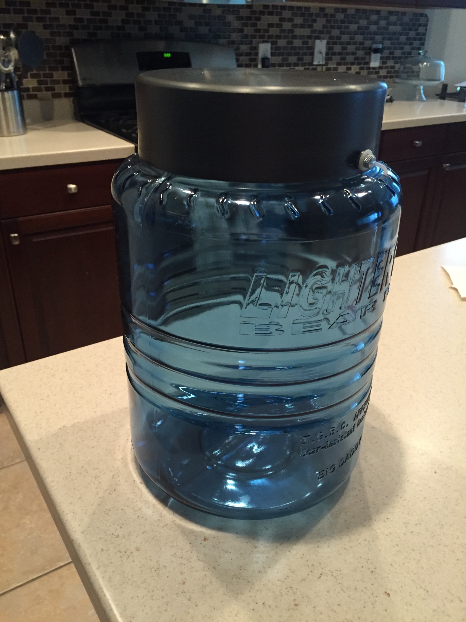 I also had to buy a bear canister. These are mandatory on the JMT for, I presume, fairly obvious reasons. The days of hanging my food bag in a tree are over. The box that the canister arrived in had spooky-looking pictures of confused bears trying to find their way into the canister. The lid of this one doubles as a cookpot, so that saves me some additional weight.
 The device is a GPS tracker that plots a precise location through satellites. Every night, as I reach camp, I will turn on the tracker and, once it syncs with a satellite, it will send an email with a pre-written message. This says something like, “Going well, missing you. xxxx” The email will also contain my co-ordinates and Diane will be able to link to a map that shows exactly where I am. I’ll probably send one in the morning as well, if only to prove that I survived the night. Then there is a custom message that says “Delayed a little, we’re fine. Xxxx” Finally, the last message is “Had a few problems, nothing to worry about. I’ll tell you about it when I can get to a phone. Xxxx” As you’d imagine, if I pressed the button for that one, Diane would come out to California and track me down. I can almost guarantee that I won’t be pressing that button. Last, there is an alarm button that sends my location to the emergency services. Let’s hope that doesn’t happen either, though I’d be more inclined to press that one than the previous one.
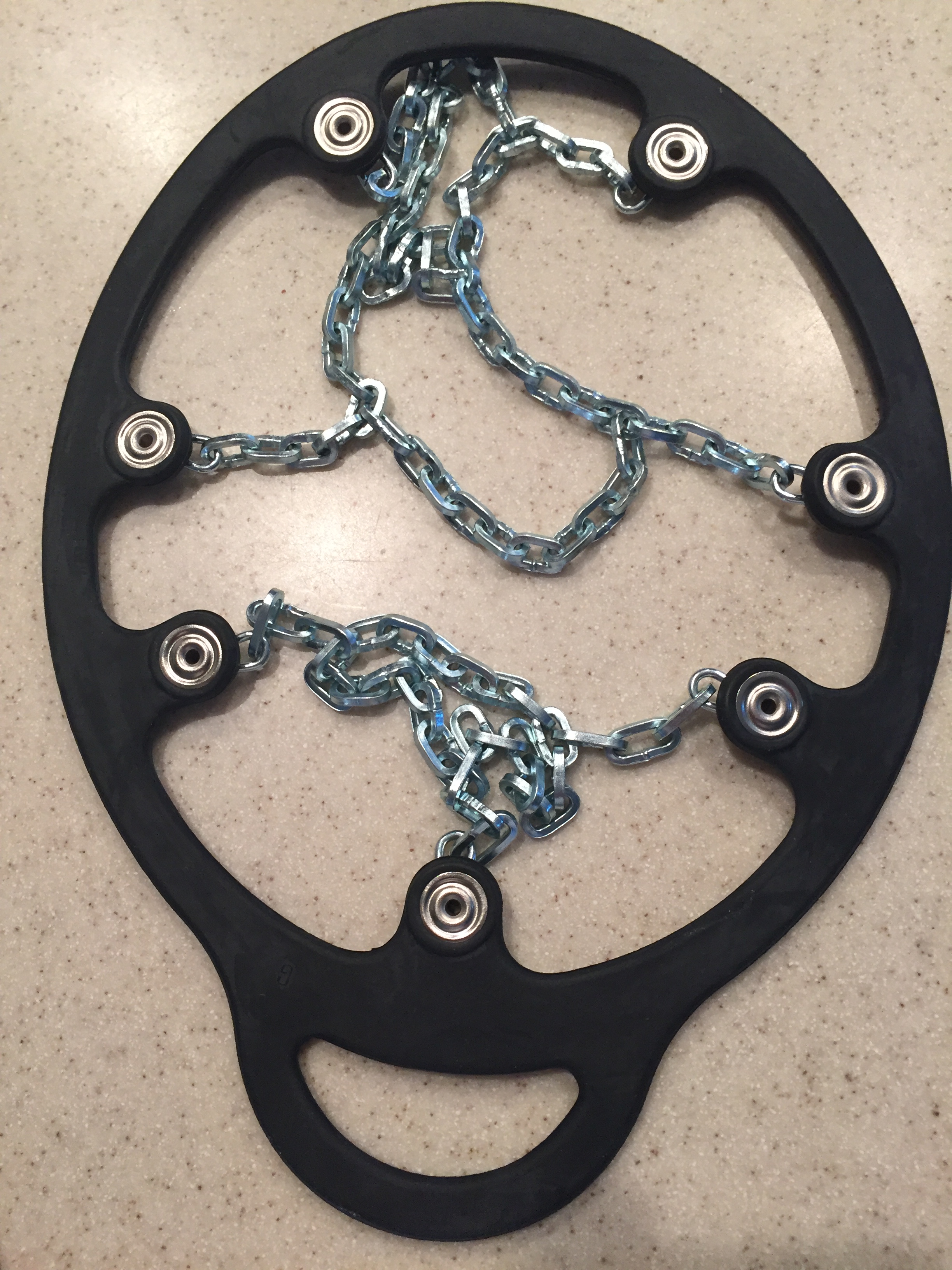 There is apparently quite a bit of snow through the high passes on the John Muir Trail this year, so I took the extra precaution of getting some snow chains for my boots. They are a bit like the snow chains you fit to your car, giving the necessary traction I’ll need to get through those passes.