Tag Archives: Appalachian Trail

Ain’t No Mountain High Enough

Sunday September 21- Monday September 29 @ 10.35am ET, Maine 15, Monson, ME – The summit of Mt Katahdin (Mile 2185.3 miles since Springer Mountain and zero miles to Katahdin)

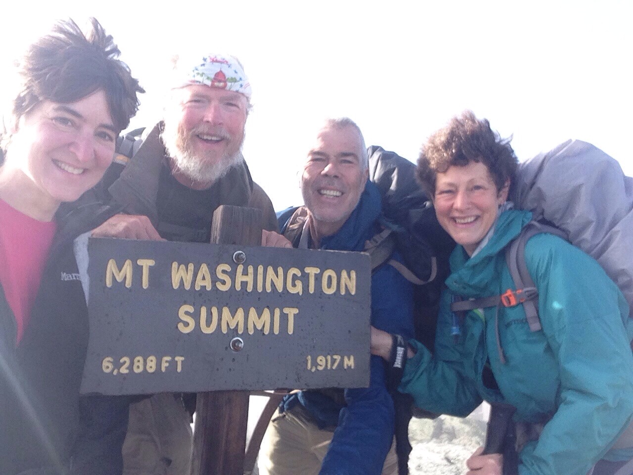
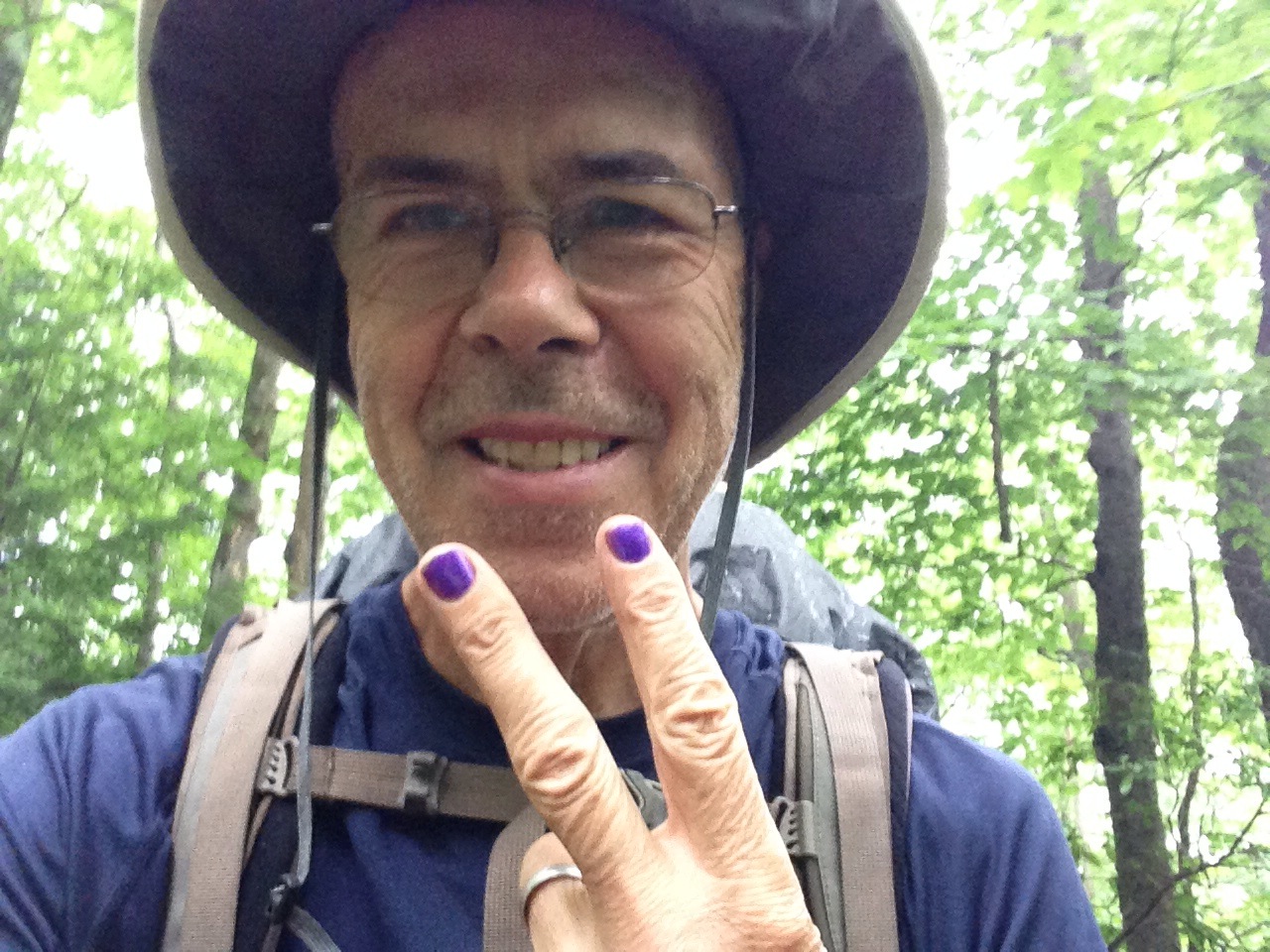
This post has taken a while to get to get round to, as it has taken me a couple of days to get to grips with my own return to reality, so I apologize for the delay. If you have followed the Facebook page, then you’ll have seen the picture on top of Katahdin and, looking at it now, I can see the relief in my face. While I knew that I wanted this to be over, I hadn’t expected my visceral reaction at the culmination of this adventure, yet it was no less intense than it looks.

The week began just before the 100 Mile Wilderness, which is neither precisely 100 miles, nor a wilderness. There is a rather dramatic sign that warns hikers to prepare to carry 10 days of food as there is no way to resupply through the wilderness, yet things have moved on since that was truly applicable.

Our team, (me, Lighterknot, Tee Bird and Trillium) had determined that it was not only easy to resupply, but it was also easy to be picked up at regular intervals and brought back into Monson for a meal in the local pub and a bed in Shaw’s Hostel. We found a terrific local guy, Buddy, to assist us in this plan, which basically went like this.

The first day, Sunday, Buddy drove us out to Long Pond Stream, which was, in Trail miles, about 14.5 miles NORTH of Monson and we were to head back southwards straight to Monson. This meant that we had an immediate ford to negotiate and, somewhat inevitably, I was the only one who didn’t quite make it, managing to dunk my boot into the stream, with a resulting “squelch” for the rest of the day. However, once that little accident had passed, we had a fairly uneventful day going the “wrong” way, with the expected rain not materializing as strongly as the forecast had indicated. I did take one or two terrific snaps and, as this is my last post, I’m going to indulge myself and add a few of them here.

image
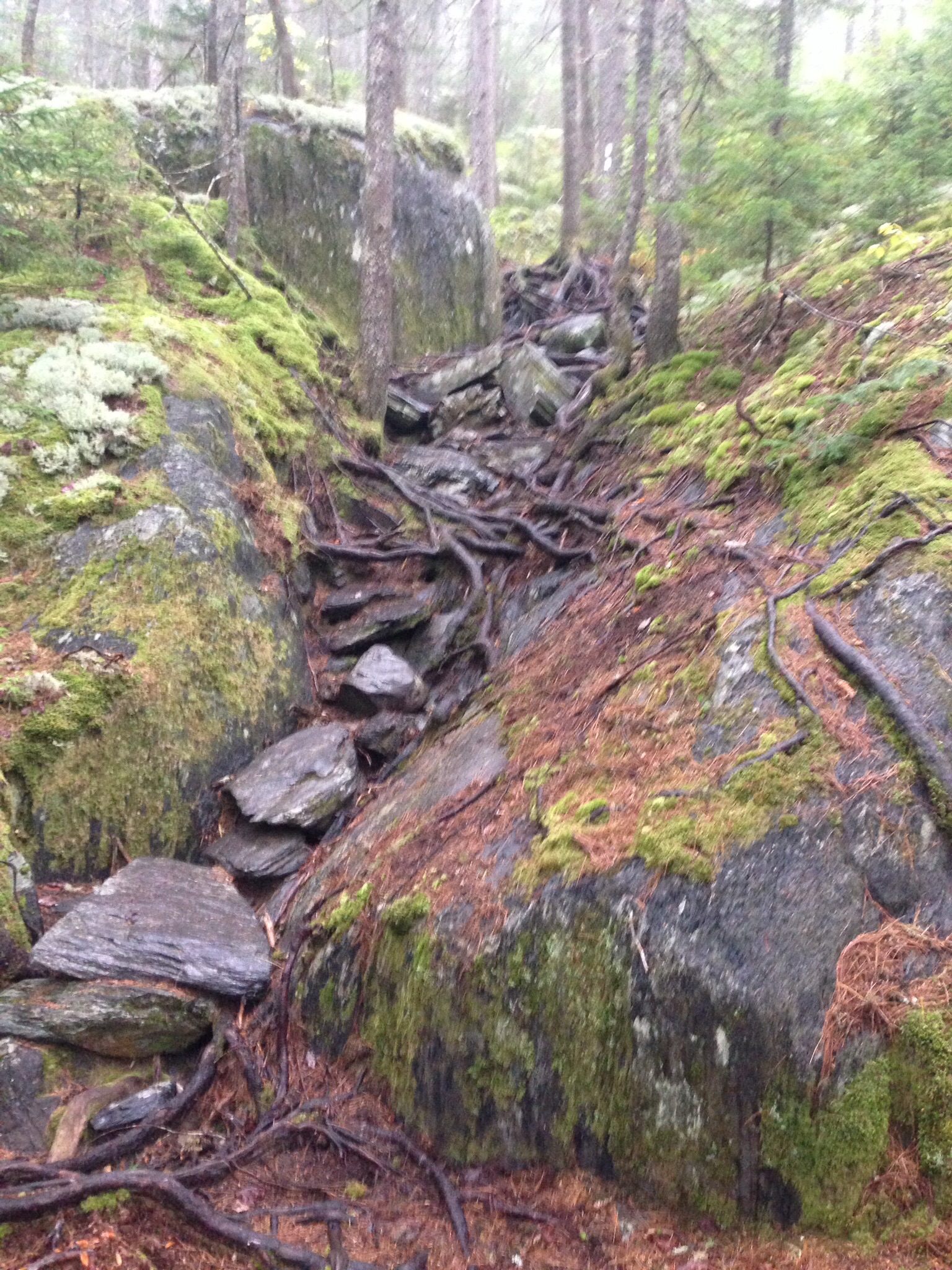
I know I’ve always talked about the difficulty of the roots and rocks, but this shows what I’m talking about, particularly when both have had either rain or dew upon them. In this case, the steady, though light, rain made them especially tricky.

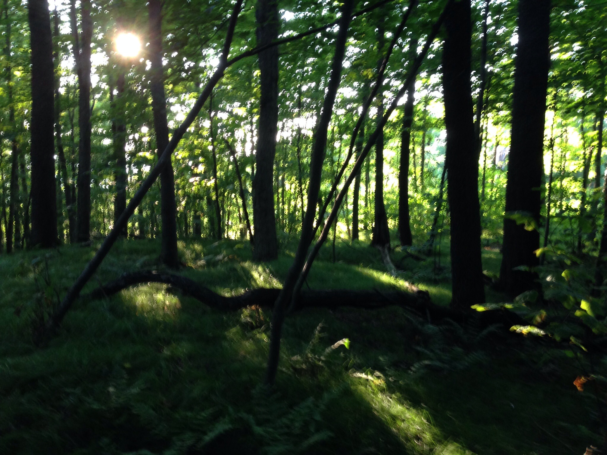
I’ve also showed the wonderful things that light can do to the forest, particularly in the early morning, so these are another couple of little gems that demonstrate this. I really couldn’t get enough of these moments on the trail.imageimage

Having done the first 15 or so miles of the Wilderness, Buddy returned to the same spot the following day and pointed us north, giving us another, slightly longer day that would end at Katahdin Iron Works Road.

It was a terrific day spoiled by one silly slip on my part. The rain had continued through the night, but it was expected to blow through after about 9am and, indeed, the weather abated after about 8.30, with the rain giving way to sun, though it remained breezy throughout the day. We knew that it was going to be a day of ups and downs, with plenty of opportunities to keep warm as we pushed uphill. There were some spectacular lake, or pond, views that continued to wow us and we were all really enjoying the early part of the hike, with the view from Barren Ledges on Barren Mountain being particularly spectacular.

We had had a cold night a few nights before and started to notice the changing colors of the foliage, with this shot from Third Mountain being the first evidence of that iconic time of year. This would intensify as the week went on.

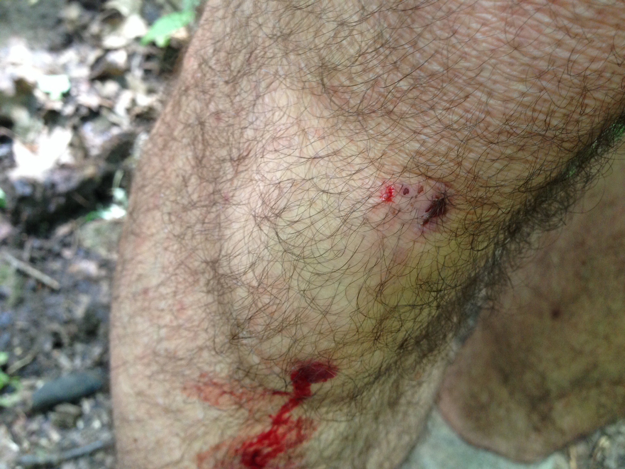
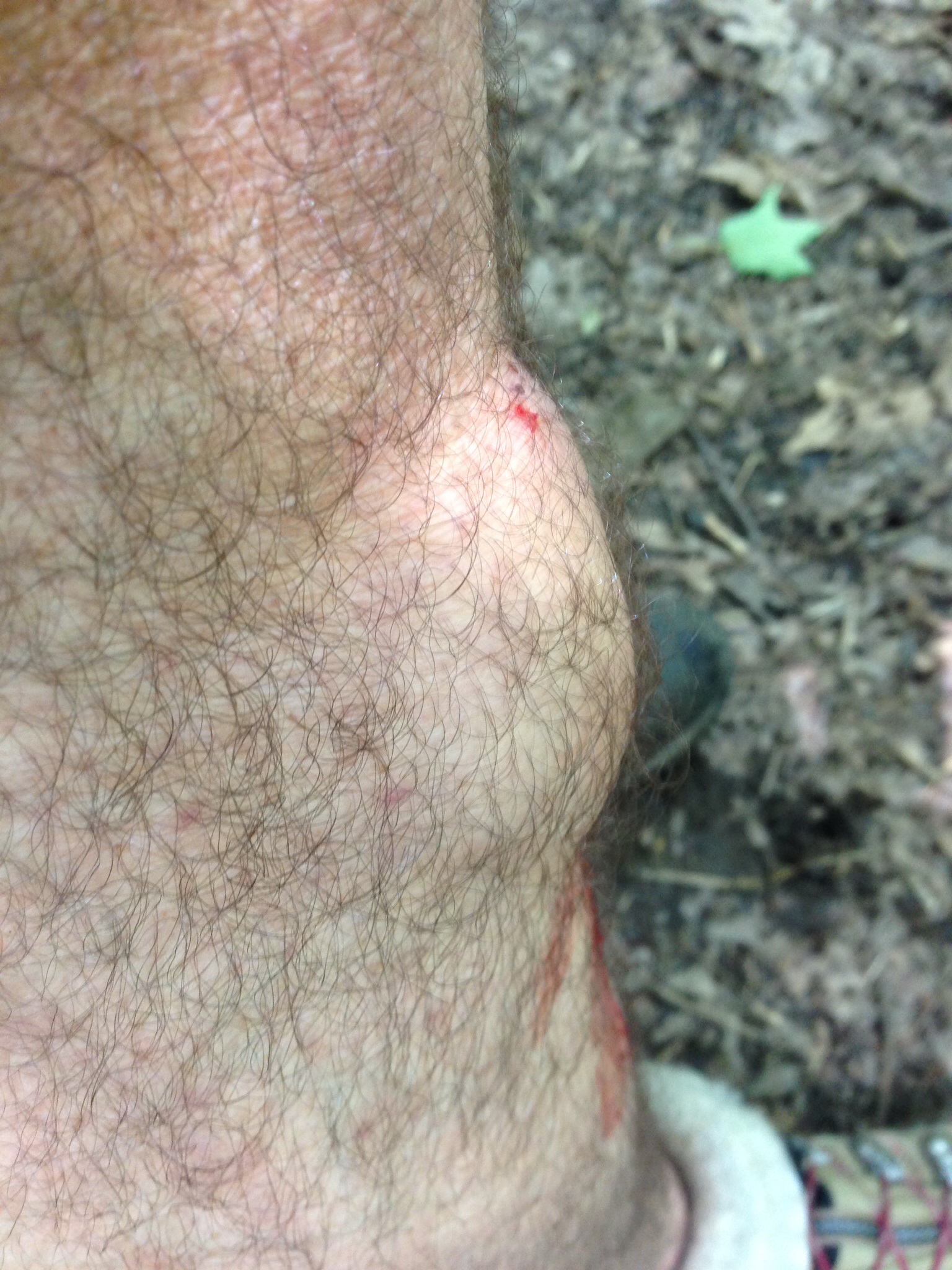
This day, though tough because of the more rugged profile of the hike, was great preparation for our legs, and we all really enjoyed the comparative severity of the day in contrast to the day before. I had just been speaking with another thru-hiker and my team had hiked on, when I slipped on a wet log that was lying in my path and flipped dramatically in the air for my 45th and what turned out to be my most dramatic fall of the trip.  As I came down, in that slow motion way that we sometimes experience, I was aware of a rock to my left and flinched at a potential collision between skull and rock. Happily for me, my head missed the rock, but I ended up wedged, literally, between a rock and a hard place, in this case, the log.

It was excruciatingly painful and I knew that I had impacted my phone in my left pocket. This actually bent the phone and gave me a bruise for my troubles. There was considerable blood coming from both arms and, once I had been pulled to my feet, I was relieved that nothing was broken, other than my phone of course.

In what has been something of a hallmark of the trip, I had no real alternative other than to carry on and did exactly that, wincing from time to time, though relieved that I was not only not dead, but also able to walk. Astonishingly, my phone, though terminally bent, continued to operate as a phone.

Buddy had judged our woefully slow walking pace and was there to meet us as we emerged, tired from going over 5 mountains but happy to have wiped out another 15 miles of the wilderness. The ride back to Monson was an hour this time, with another opportunity to fill up on calories once more.

Back in the woods the following morning, with my left leg aching sporadically, we had another 15 miler that took us over the last high mountain before Katahdin, White Cap Mountain. Another great view and a self-indulgent selfie followed, this time without my trusty stic-pic to extend the view, as the case had shattered in my fall the previous day.

This time, we emerged at West Branch Ponds Road, a full two hour drive from Monson, including an 18 mile bumpety bump along a dirt road used by logging trucks. This drive had to be repeated the following day, with our last slackpack with Buddy, as he was staying in the area for a bit of fishing before meeting us once more, this time at Jo-Mary Road, to load us up with our full packs for the last time. In this way, we got through the more mountainous part of the wilderness and preserved our knees for our impending assault on Katahdin, which means “the greatest mountain.” On the way to meet Buddy for the last time, we were lucky enough to stop by the deliciously calm Crawford Pond and shoot the developing colors of the foliage.

Getting to grips with our full packs once more at the end of another satisfying day, we tried to find a campsite in the woods, as the light was beginning to fade. Luckily, I spotted an opening up of the path and found a spot for a couple of tents for me and Lighterknot, while the women moved deeper into the forest to set up about 50 yards from us. Once more, it was great to be back in the woods and I sat on a log and prepared my pasta, with only the twittering nuthatches as company; it was gloriously calming.

Looking at our maps, we headed for Nahmakanta Lake Campsite, another 15 miles north, yet were rewarded once more on the way with another gorgeous lake, Pemadumcook, for an awe-inspiring view of our ultimate goal.

Believe me, as the four of us were joined by another few hikers, this view quietened us all down as the reality of our imminent success dawned upon us. The fact that our target seemed to be increasing in size as we got closer made us all focus on the job ahead and, once sated with the magnificent view, we sped on to Nahmakanta Lake.

I absolutely LOVED Nahmakanta Lake. We got there earlier than usual and, having set up camp, hung out on the stones beside the lake and enjoyed the afternoon sun as it dropped slowly out of sight to the west. I was mesmerized by the peace of the place and sat for over an hour on a rock thinking about my time on the Trail and my hopes for my return to Diane. I shot this video and, thankfully for you, resisted filming much more! Maine has proved to be the most beautiful state and, in conjunction with New Hampshire, the last two states have been the highlights of the trip for me.

We were lucky enough to find almost as great a spot the following day, setting up at Rainbow Spring Campsite, after a fairly flat profile that allowed us to enjoy the day and not wear us out. Earlier in the day, as we were leaving Nahmakanta, the path took us out of the woods for about 200 yards and led us along the beach around the lake for that short distance. Of course, I recorded this unexpected treat before we dived back into the woods.

Sadly, I wasn’t able to grab my camera in time to record two moose that suddenly emerged from the bushes about 25 yards ahead of us. There was a mother and her calf (apparently from the bovine family), and we watched open-mouthed as they sauntered back into the woods to continue their assault on the limitless leaves. I may have said it before, but seeing the majesty of such animals in their own, very comfortable environment is very humbling and reduces mankind to awestruck onlookers.

No apologies for showing that evening’s campsite attraction, where about a dozen hikers, mainly thru-bikers but also some section hikers, gathered to watch the sun go down. The following morning, I got there early, by myself, and filmed as the sun pulled itself up to light up the trees on the opposite bank. I’ve been really appreciating my time alone and marveling at the glorious displays that nature is granting me.

It was now Saturday and everybody was feeling the growing anticipation of Monday’s climb, appreciating the beauty of the past few weeks, yet ready to go home and keenly aware that Monday was forecast to let us down with a 50% chance of rain, having rewarded us with stunning weather all week with both Saturday and Sunday expected to continue in this vein.

The walk out of the wilderness, to the deeply unattractive Abolimage
Bridge, was easy and mainly flat, with a wonderful little trip over Rainbow Ledges that gave us another glorious shot of our goal though, amusingly, Tee Bird and I spent about 10 minutes trying to identify Katahdin, only to find a few minutes later that we had been looking in precisely the wrong direction. The real thing, as you can see in this picture, wasn’t to be misidentified.

I’m not sure if it was the anticipation of the finish, or the accumulative effect of my 45 falls, but I was really struggling on what should have been an easy day and, when I mentioned this to Lighterknot, he felt exactly the same, so we presumed it to be the former.

imageThe only real attraction to Abol Bridge is the fact that there is a campsite and restaurant, where Lighterknot and I demolished burgers for both lunch and dinner. However, the view from the bridge itself was pretty darn wonderful, as you can see.

I left it a little too late to take advantage of the shower that evening, so hurried into it at 5.30 the following morning. Unfortunately, I was completely unable to make my chosen shower work, so gathered up my clothes and darted across the room to the other shower before failing miserably with that one as well. As a consequence, my trip up Katahdin was going to take place with the added weight of a week’s worth of accumulated sweat and grime and a shirt commensurately filthy.  Nice.

The traditional camping spot for the night before the climb is only 10 miles from Abol Bridge, in Baxter State Park at the Katahdin Stream Campground so, with only a flat 10 miles to go, we took our time and even detoured to yet another pond, Daicey Pond and yet another stupendous view, this time while sitting on a rocking chair.

On arrival at the campground, there was a palpable excitement around us, as hikers were on their way down from that day’s ascent and we greeted them as enthusiastically as heroes returning from combat. By now, we all had a huge mutual respect for one another and were delighted to see our fellow hikers achieving what we were hoping to achieve in 24 hours time.

Trillium’s partner, Jon, had booked a lean to for the two of them and, as Lighterknot had been met by his wife Deb and his mom, Mama Jean, they were going into Millinocket for the evening. Trillium and Jon let Tee Bird and me pitch our tents outside the lean to and we were in a great spot to greet and talk with the hikers as they returned with their stories of the day’s climb. Unfortunately, just as dusk was upon us, a ranger came by and told us that we weren’t allowed to camp there (even though we were in nobody’s way) and that we had to move about 20 yards further down. For that privilege, we were also charged $15 each. Despite getting particularly British on him, he wasn’t to be moved, so I had to accept the inevitable and drag my already erected tent to a new spot. I wasn’t happy.

Earlier, the same ranger had taken my registration to climb the mountain and recorded me as the 699th successful thru-hiker of the year (this appeared to be a little premature to me).  Apparently. between 3,000 and 4,000 had started in Georgia, though numbers aren’t yet finalized.

That night, I was unable to sleep too much and actually sat up in my tent to contemplate what I was about to achieve. Funnily enough, one of the things that mattered to me most in those moments was the fact that my son, Rob, was going to accept my trail name, Mighty Blue, having insisted, not unreasonably, that I couldn’t claim to be mighty before I’d taken a step. However, he had already started calling me”Almost Mighty Blue” for a couple of weeks, so I knew that I was on the right track.

I also thought of what I was going to do when I returned to Florida and had the luxurious feeling of not knowing and being entirely open to anything that might come my way. That is a surprisingly attractive feeling to have.

Above all, of course, I was relishing my return to Diane and getting on with our lives. Stepping outside of your marriage, albeit with your partner’s blessing and support, is a strange thing to happen in a happy marriage and I will always be grateful for her buy-in to my adventure.

In the morning, Trillium and Jon headed out at 6.20, while Tee Bird and I left with Lighterknot at 6.50.

The going was easy for a mile or so, while the weather cooperated, though it was cloudy on the mountain. We started to climb gradually and, while it was arduous, it was hardly out of our capacity and we made great progress for a couple of miles. As we got higher, the trees became more sparse and we emerged above tree line with plenty still go climb and started to hit the rocks.

Suddenly, we were into real climbing, with hand over hand stuff that required thinking about as we negotiated our way up steep rocks and pulled ourselves up using metal bars driven into some of the trickiest passages. New Hampshire had prepared us well for this and I was really in my element, enjoying it hugely as we made our way ever up.

Eventually, we emerged onto flatter ground, though the cloud had really enveloped us by now and we stuck together as we continued ever upwards. Excitement was mounting and, even though we heard voices ahead, the end kept being delayed as another crest appeared ahead of us.

Then I heard a more prolonged chatter and excitement and, with about 75 yards to go, I was able to see that iconic sign, the sign I’d dreamt of for years and the sign that had been a constant in my thoughts for the past 6 months. As I drew nearer, I thought of Diane and my sons and had quite a lump in my throat, though, as I touched the sign to signify the end of the trip, I simply felt grateful and relieved that I hadn’t been injured or worse.

In seconds, I had taken pictures of Tee Bird on the sign, then climbed up to it myself. The relief flooded out of me as I let go a full-throated roar of achievement and delight, the pictures recording what I was feeling. I then called Diane and Rob, with both conversations ending in my tears, particularly with Rob referring to me as Mighty Blue for that first time.

image

The rest is just something of a blur, though it was important to descend carefully and we did just that. I don’t feel the need to write about the descent, as it doesn’t count towards the AT, though I concentrated throughout to avoid the ignominy of a calamitous fall after the glory, so to speak.

Lighterknot and his family took both Tee Bird and me into Millinocket, leaving me at the Appalachian Trail Cafe, where I spent a muted hour with yet another burger before being kindly run to Bangor Airport by the very kind Tim and Vickie Edwards, members of the local Florida ATC Club in Sarasota.

An early flight the following morning saw me home by lunchtime.

I haven’t had the opportunity to fully digest what the Trail means to me and I imagine that I’ll need a few weeks to put it in some perspective. However, I feel that I have undergone something of a catharsis that will likely fully manifest itself in the days and weeks to come. For now, I’m delighted to be back with the woman I love and pleased to have shared my journey with so many. I hope that you take the positives from this story and that these outweigh the negatives. At the end of the day, that is as good a result as any of us can wish for.

Hit the Road, Slack.

Friday, September 5 – Saturday, September 13. Route 2, Gorham, NH – Caribou Valley Rd, Rangely, ME (Mile 1988.8 miles since Springer Mountain and only 196.5 miles to Katahdin)

It’s been a while since I was able to post and I’m now appreciating quite how remote Maine, indeed New Hampshire as well, can be.

We left the White Mountain Lodge and Hostel after a big breakfast and some regrets, as it was another one of those gems on the trail that always take you by surprise.

With the Whites behind us, we took some relief from the gentler incline at the start of the day, though gentler is merely a relative term and not to be interpreted as gentle in any way, as we were all sweating profusely within minutes. This was partly due to the incline and partly due to the warmth and humidity of the day. Of course, the higher we got, the cooler it became, so it was a terrific start and we covered over 6 miles before stopping for lunch. We had all over-shopped at Walmart the previous evening and went about reducing our increased load by consuming as much as possible.

I seem to have developed a somewhat unhealthy fixation for Snickers and Peanut Butter and will need to curb this rather disturbing habit in the near future if I’m not going to end up back at 250lbs by the end of the year.

Given our new group of 4, we’ve had to adjust the length of our potential mileage and had to settle for Gentian Pond Shelter, at just over 11 miles. We put up our tents on tenting platforms, which are wooden slats set level with the ground, thus obviating the need to find a flat spot on the ground. Very helpful to somebody like me, as I remain incapable, even after all this time, to find any level ground at all, often to be found in the morning tangled up with my pack in the bottom corner of the tent.

We left Gentian Pond just after 7am with 2 targets imminent. The first, the 1900 mile marker, was upon us within the first hour, yet the second was probably most significant as we moved into Maine, our 14th and last State. For months, I’ve refused to think too much about Katahdin, as it was so remote and in the future, yet here we are, in Maine. So I’ve allowed myself the luxury of imagining my picture at that iconic sign. It feels good to allow myself to add some reality to the fantasy.

I also notched up another fall, this one being the 36th time, catching my bent knee under my body. I’d been feeling particularly sore in my left knee just before I slipped and, rather amazingly, the knee felt relieved after, as if the fall had stretched whatever was ailing me. I’m aware that my falls are increasing with the difficulties we have encountered in New England and I’m really trying to be careful and avoid a bad fall that might jeopardize my hike.

Trillium had arranged for one if her partner’s relations, Geoff, to meet us at the end of a 2.5 mile side trail and take us back to his cabin in the woods. He was going to slackpack us through the Mahoosuc Notch the following day, which meant that we had the luxury of only taking a daypack and returning to his cabin that same evening.

Geoff has a rather chaotic, though cosy, home and he made us all feel very welcome, with Lighterknot and I on the floor while Trillium and Tee Bird took the sofas. While he doesn’t hike himself, he knew that hikers are generally ravenous, so went out to get some food at a local restaurant, returning with both a burger AND a meatloaf meal for Lighterknot and me.

The following morning, as Geoff drove us back to the side trail that would lead us back to the AT, clouds had formed over the mountains that looked like a comforter thrown over them. This augured well for the rest of the day, as there was a glorious blue sky everywhere else and we knew that the sun was steadily burning the comforter away.

The Mahoosuc Notch is a collection of huge rocks, making up a puzzle for hikers that is about a mile long. There are choices to be made as to whether to go over, go round, or even go under rocks as we threaded our way through this mile of mayhem. It was a lot of fun but took us nearly 3 hours as a team. Once we had negotiated that, there was an extensive climb up Mahoosuc Arm, so that, by lunchtime, we had only done just over 2 miles of the trail.

The sun had done its job and we were rewarded for our hard work, as so often in New England, by a glorious view at the top.

As the afternoon progressed, I fell twice more, for my 37th and 38th tumbles. The second was fairly uneventful and didn’t hurt too much, though the first was one of my worst falls.

I was pulling myself up a very steep, sheer rock face and had just left the comfort of a tree root that I’d been pulling myself up with to get to another one, when I felt my boots slip slightly on the rock. I thought I’d steadied myself and made the fatal error of relaxing for an instant, only to take off, like a giraffe wearing socks, sliding down, then falling about 15 to 20 feet, badly banging my hip as I fell. I always shout out the number of the fall as soon as I realize that I’m not bleeding and nothing is broken, yet this call was accompanied by a grimace as I felt the pain. There never seems much point in hanging around in these circumstances, so I got up and got on with it as usual. Happily, everything worked as before, though the hip hurt like blazes every other step.

The climb down after a few more gorgeous ups was 3.5 miles and seemingly endless. Eventually, we met Geoff just before 7pm and he took us for an excellent Chinese meal.

Geoff had to drop us off early at Grafton Notch the following morning, as he needed to get to work, so we loaded our surplus stuff into bags and left them to be collected by the folks at The Cabin, our next stay, in Andover.

Once more, with lighter packs, the hiking was easier and we made our way up the glorious Baldpate Mtns, East and West. This part of the trail took us above tree line, which I love, so the resulting video is pretty darn nice.

As you can tell, slackpacking had become something we were getting used to and we became aware that the majority of our fellow hikers were doing the same thing.

By now, Tee Bird had emerged as our booking agent and she had arranged for us to be met by Earl, or Bear, the proprietor of the Cabin. Bear and his wife, Honey, or Margie, have run the Cabin for 20 years and are 2 of the loveliest people on the trail. They are both in their 80’s and expect to be closing at the end of this season, as they are starting to feel their age. Hikers will certainly miss them.

The highlight of the stay is the dinner, which is served family style around a huge pine table, with Honey and Bear presiding at the top of the table, soaking up the stories and jokes of the hikers. The food is great and unlimited, with Bear pushing us all to eat more. It was a great evening for each of the 3 nights we stayed there, with friends old and new providing a changing cast of characters each night.

Breakfast is similarly unlimited and I had 8 pancakes the next day, along with eggs, sausage and home fries. Bloody marvelous!!

There was only room for 5 people in the cab of Bear’s truck the following morning, so I chose to sit in the open at the back of the truck. There were 4 garrulous women in the cab, plus Lighterknot so I preferred a quiet ride! The truck back fell open as we were going uphill, so I had to grab packs and poles to stop them falling out.

When Lighterknot got out, he was shaking his head and muttering, in his heavy southern drawl, “I should have sat in the back!”

The way the roads are configured limits the amount of miles we could do, so we had just another 10 Mike day that ended with a very tricky climb up near the end and a resulting perilous climb down Moody Mountain, with Bear meeting us at the end again.

The third slackpack out of Bear and Honey’s was a more respectable 13 miles, with Bear telling us that we would likely finish at 5pm. The old boy knows his stuff, as I emerged at Maine 17 at exactly 4.59pm, giving me a stupendous view from the small parking area.

That last evening at the Cabin, 2 of the Rocky Pizza Challenge participants, Hawkeye and Buchanan, showed up, the first time I had seen either of them since Tennessee.

We had made arrangements to move on to Rangely and stay with Shane and Stacey,at the Farmhouse. This has been another terrific stay, and we were able to continue our food fest by sampling the local restaurants for 3 days. Shane has slack packed is for 2 days this far and we are now down to less than 200 miles from Katahdin. Indeed, we’ve now worked out our likely finish date of 9/29.

One highlight of the past couple of days has been Saddleback Mtn, though it was clothed in clouds when we summited, so I took this video from its younger sibling, Saddleback Junior.

We’ll be moving to Stratton tomorrow and all the hikers now around us are eager for the 100 mile wilderness then the finish.

I told Diane of our expected finish date and she is looking for flights. It’s getting near and I hope you’ve been enjoying the journey with me. New Hampshire and Maine have been wonderful, while slackpacking has certainly saved my knees from too much punishment. However, we’ll be back to full packs shortly, so that should keep me interested till the end!

All The President’s Men (and women)

Monday, September 1 – Thursday, September 4. Lake of the Clouds Hut – Route 2, Gorham. (Mile 1887.0 since Springer Mountain and only 298.3 miles to Katahdin)

The Lake of the Clouds Hut has a reputation of being one of the friendliest huts in New Hampshire and, despite a few reservations, we were treated well. We were able to stay in the hut overnight by doing “work for stay.” This variant of “work for scraps” involved more work, including endless washing up (by me, in a sink designed for a midget) and fridge cleaning (apparently long overdue) though we were fed very well and allowed to sleep in the dining room, in most cases on the floor. I was able to snag a bench and settled down for what proved to be a disturbed night.

My reservations are more about the disregard us “hiker trash” have to put up with, though I may be being a little hyper-sensitive. That said, we rarely see a raising of the flag when we arrive bedraggled and wet!!

We were dreading first light, as we knew the tenor of the day would be set by the weather conditions. The climb up Mt Washington was immediately in front of us and we set out when we saw breaks in the clouds and the sun trying to force its way through. This turned out to be a great decision.

I’ve been hiking so much better in the Whites and I set off like a train, pushing on as the scenes revealed themselves in front of us. This video captures my excitement once more.

We were expecting the weather to close in on us, asimage there had been snow the day before at the summit though, once there, after a quick team snap, we found the snack bar and topped up our sugar and calorie levels once we’d savored the experience at the top. Given the weather forecast and the unpredictability of Mt Washington, we moved on, heading for the next hut and, ultimately, the Osgood Tentsite.

Trillium and Lighterknot were a little slower than me and Tee Bird and we all enjoyed the remarkably mild day and occasional break in the cloud that showed spectacular views. This is one from Mt Adams, followed by a daunting one of Mt Madison, our after lunch target.

This was the next target, with its pinpoint summit.

At the next hut, we lunched inside and braced ourselves for the steep climb up Mt Madison and the following, far longer, descent. Another exhilarating climb saw me at the top before the others and, as I was at the very small summit, I launched into a gorgeous, though precarious 360.

The descent was probably the toughest we’ve done so far, climbing down nearly 3,500 ft over 2.5 miles. It was a bloody awful time and really messed up everybody’s knees. We gratefully found the Osgood Tentsite and Lighterknot and I set up on one tenting platform, while Trillium and Tee Bird set up on another one. These platforms are made of wooden slats that give a nice level ground and obviate the need to find an otherwise flat spot. Trillium had somewhat lost her humor at this point, so we had a quiet evening and crashed early

We’ve settled into a kind of routine, breakfasting, packing up and leaving by 7.30am. Given the time it takes to do a mile in the Whites, particularly in the Presidential Range, we need to hike for about 10 or 11 hours to do pretty much the same number of miles.

Our first target the following morning was Pinkham Notch, where we had arranged to meet Shepherd once more and refill our food bags. The terrain didn’t seem too bad, though I struggled quite a bit and was happy to get there, even though it was less than 5 miles. That said we got there in less than 3 hours and immediately hit the snack bar for a very substantial sandwich and various sweet goodies before consolidating our food bags.

You may recall in a previous post that I had talked Stardust “off the ledge” when she was contemplating quitting and I was delighted to see her again, at Pinkham Notch, happy and hiking with a bunch of friends. It made me feel all paternal!

I had been trying to make do with a single trekking pole after the previous day’s accident, but it really makes a difference when you are used to both, so I splashed out $100 to buy a decent, though not best, set of Leki poles. The effect was immediate and I really got stuck into the hike up from Pinkham Notch. It was a substantial climb up to, eventually, Wildcat Mountain, followed by a steep downhill mile to Carter Notch Hut. We offered to “work for stay” but, with only one guest, they didn’t need us to work but allowed us to sleep on the floor. There were eventually 7 of us crammed into the dining room, while I put 2 benches together and used them for my bed. That’s living!!

After a fairly sleepless night on my bench, the following day turned out to be a great mileage day, yet one that was, once more, very painful on all our legs. We had to be packed up by 6.30am and out of the hut by 7, so it was an early start to the day.

The climb up Carter Dome was the most intense of the day, with about 1500 ft elevation gain in just over a mile. However, we all seemed to be ok with this, despite some tough hand over hand stuff. We were rewarded with absolutely no view once we got to the top, as we found ourselves in the middle of a cloud.

For the next couple of hours we were going along the ridge, sometimes up, sometimes down, before we came to North Carter Mtn and the truly ferocious descent on the north side. This was basically sheets of rock, wet from the overnight rain and ready to catch the least aware of us.

I led the way, trying to find the least dangerous route down by a combination of rock hand and footholds, tree trunks, branches and even exposed roots, along with a heavy slice of luck. There were several times that I slipped, but was always able to recover sufficiently to steady myself and help the others. I found it exhilarating, though it was playing havoc with both my knees.

We eventually made it to the Imp Shelter, at which time we had lunch and ran into a couple of hikers I hadn’t seen for several weeks, Nobo Hobo and Caddyshack. Over lunch, we decided to push on to the Rattle River Shelter, which meant a climb up and over Mt Moriah followed by another long downhill.

Trillium and Lighterknot were struggling by the time we eventually got to the shelter and we decided we’d camp and treat the following day as a “nero,” with just a few miles into town and staying at a hostel.

For me, this was a significant decision, as I pretty much put my September 25th finish beyond me. I’ve reasoned that hiking a little slower with a team is far safer than hiking a little faster by myself. This is disappointing, though probably sensible and I’ve squared the decision with both me and Diane. I want this to be a life-affirming trip as opposed to a life-threatening one.

Another safe night and we were happily marching on the way out of the White Mountains with hardly a scratch. We have had incredible luck with the weather, only being rained upon when we were safely tucked up in huts. I couldn’t imagine how difficult these mountains would be if there was consistent rain and the rocks were always slick. As it was, despite a little bit of slickness on a couple of rocks, and roots, I’ve had a blast.

I’ve been thinking about changes I’ve made to my diet, as I’ve gone from 4 high protein bars a day to 4 Snickers or Cliff bars, with a high protein bar at the end of the day once I’ve stopped hiking. Trillium suggested this as a better way forward following a conversation she had with a nutritionist and I certainly feel far more full of energy. That said, I started taking multi-vitamins at about the same time, so it may be that. However, as they say, “if it ain’t broke, don’t fix it,” so I’ll carry on as I’ve been doing and hope to get to the end as well as I feel now.

We are currently neroing at the White Mountains Lodge and Hostel, near Gorham, an absolute bargain at just over $30, with laundry, working wifi and your own proper bed, as opposed to an exercise in scumminess at some other places I’ve been in.

imageTo keep the place clean, the rules are that no packs nor boots are allowed indoors and hikers get out of their filthy clothes and wear clean hostel clothes. As you can see, it’s quite a look.

Marnie and Marnie’s mum (Molly) really make you feel at home and give two shuttles a day to stock up and fill your face, both of which we’ve been doing. It is only when you shower and generally clean up that you realize you are still part of the civilized world, a good indicator for anybody, I feel.

We are nearly out of New Hampshire and now have less than 300 miles to go, though we are aware of the challenges that Maine poses. That said, I am hiking better than at any time on the trip and NH has far exceeded my expectations.

I hate to make predictions but, injury aside, I’m going to complete this and, to be honest, I’m going to be proud of the effort when I’m standing there, grinning like an idiot at the top of Katahdin. This trip has tested me more than I can ever relate to you and I’m sure further lessons will be revealed once I can put the whole thing into perspective with the distance of time. I would urge anybody to do it as long as they understand that this is a full six month commitment to something they want to do more than anything else. Once you make that commitment, you’re almost there (apart from the 2200 miles, which still need to be hiked)!!!

The three amigos

Friday August 22 – Monday August 25. NH10, Hanover, NH – NH25, Glencliff. (Mile 1786.4 since Springer Mountain and only 398.9 miles to Katahdin)

IMG_3349-0Brian and Dee’s son, Stewart, kindly drove me back to Starbucks, where he had picked me up on the Wednesday evening. It had been great to take a zero and I was very grateful to Brian and Dee for their hospitality.

Of course, at Starbucks, I couldn’t resist the chance of a triple grande non fat latte (old habits die hard – I should have had full fat) and a Blueberry scone, so I dallied for 30 minutes before hitting the trail once more. It was spitting with intermittent rain as I started, though I’d been warned by the forecast.

Happily, what rain there was eased off and my first impression of hiking in the woods of New Hampshire was that it was all fairly benign. Something of an uphill to begin with but nothing too terrifying. I knew that this was an entirely false impression but enjoyed deluding myself nonetheless. Until you have to face it, convince yourself it’ll be ok!

I ran into a couple of familiar faces that morning, starting with Voodoo, the witness of my most embarrassing moment on the trail (so bad, that I couldn’t write about it and simply described it in a video), and Lighter Knot, an older guy I’d camped with in CT. Lighter Knot and I talked about possibly teaming up for some of the tougher climbs to come. We said we’d meet later at Moose Mountain Shelter and decide where to end the day at that time.

As luck would have it, by the time we got to the shelter the rain was just starting to take hold, so our day was over after only 11 miles by 3.05pm.  A Japanese guy who Lighter Knot knew, Loon, joined us later and we were all settled in the shelter by 7.30. I don’t normally sleep in shelters, though I make an exception when it rains.

While the rain itself subsided, the wind through the night blew water from the trees on to the shelter, drowning out any mouse or chipmunk activity, which was fine by me. They may have been marching round and poking into our packs, but as long as I can’t hear them, I’m food to go.

I had probably my best night in a shelter and woke refreshed and ready to move on. I was out by 7.50, making excellent progress for the first 5 miles. The real mountains were still to come, yet I really struggled for the rest of the day to make another 7 miles. They tended to be pretty much straight up, with no side-to-side and I took extensive breaks, gasping to regain my breath and the power in my legs. That said, there hasn’t been a mountain I’ve failed to get over, so I take heart from that.

Lighter Knot and I stopped at the kindly Bill Ackerly’s home (just look at the cute sign that he made) at theIMG_3368 promise of free ice cream and water top up. Bill is a real gent, 86 years old and delighted to have hikers cluttering up his porch.  He claimed that it was his 86th birthday, though one of the hikers who had been there the previous evening said that he had said the same thing the day before!  He was a treat to meet.

I got to the shelter, which was a very dreary, closed building and waited for LK before we settled on the tenting site, a few hundred yards before, with a beautiful view.

I had my best sleep in a tent in a long while and breakfasted with a glorious view in front. Lighter Knot left 10 minutes before me and called at the shelter, where he hoped to, and did, find Loon. We had arranged to meet at the tentsite at Ore Hill, about 12.5 miles away, so I tried to make some early progress down the hill.

image

It was wet, rocky and very muddy. Indeed, I fell for the 27th, 28th and 29th time, each time slipping on the mud and all the falls occurred within an hour. I didn’t hurt myself on any of the falls, but they still always slow me down and tend to make me more tentative, though clearly not tentative enough, as I continued my fall fest.

I ran into several SOBO’s, many of whom were eager to share their stories of the White Mountains and Maine. It all sounds like a bit of a horror story to me and I feel for the first time that I may miss my September 25th target date. My lovely wife always tells me that she would rather I missed her birthday and stayed safe, so I’m going to concentrate on the safety while still keeping an eye on the miles per day. You never know, I may still make it.

There were two good climbs today, though nothing I haven’t experienced before, and I got to camp at about 4pm, while Lighter Knot showed up about 30 minutes later and Loon rolled in at about 6.30pm, though he probably left about 2 hours after us. I must say, knowing that I won’t be camping alone is quite a pleasant feeling, so I may have found the partners I was previously avoiding.

With my new amigos, Lighter Knot and Loon, around me, I slept really well again, waking after 6.20am and refreshed once more.

We had decided to hike just to Glencliff, only about 8 miles away, for a couple of reasons. First, I had a food pick up from the Glencliff Post Office. Second, Mt Moosilauke is the beginning of the White Mountains and LK and I wanted to slack pack our first mountain in that range. We’ll be doing that tomorrow morning.

Slack packing involves a small day pack, with the hostel taking hikers to a specified point ahead on the trail, then hiking back to the hostel. In this way, we’ll be hiking Moosilauke from north to south which, from the profile, looks to be an easier route.

There are a varying number of attitudes to this type of hiking, some believing that it isn’t somehow “correct.” My attitude is that you take what you need for each day and, when you are returning to sleep at the same place, you only need a small pack, with water and some food with, perhaps, an article of clothing. This is where “hike your own hike” prevails, so I’m happy with our decision.

While the three of us hiked separately today, the three of us got to the end of our morning effort at the same time and headed east. We reached the Hikers Welcome Hostel within half a mile. It was a little like Standing Bear Farm, which was more than 1000 miles back, where nothing looked right but it all worked. A shower, laundry, tent site and shopping trip allowed us all to hang out for the afternoon, chatting with SOBOs and even one guy who is boomeranging. Incredibly, he started on Springer on the same date as I did and has been to Katahdin and is heading back down south!  Nearly 4400 miles in one year!  Extraordinary.

I’m looking forward to Moosilauke in the morning and, with a great forecast for the next 5 days, we look set fair for the Whites.

Bring ’em on!

Chillin’

Monday August 18 – Thursday 21. Sherburne Pass Trail – NH10, Hanover, NH. (Mile 1743.1 since Springer Mountain and only 442.2 miles to Katahdin)

This is a bit of an experiment, as I’m trying to post using my iPhone instead of my iPad. If it works out, the iPad goes home and I save about 1.5 lbs in my pack. Every little bit helps!

After staying overnight at the excellent Inn at Long Trail, I had to hike for 0.5 mile to get back to the AT. I knew that I’d be crossing the 1700 mile barrier within a mile or so, though physical markers had been missing for the past 400 miles. Of course, this time, there were 2 markers, about 200 yards apart and I snapped pics of them both for Facebook.

The magnificent Kent Pond was my companion for about 30 minutes early on this day, as the trail curled around it, affording me some glorious shots of what the Brits would call a lake. I have constantly been struck by
how the beauty of everything is magnified by sunshine; it’s like nature’s own Windex, washing everything to a sparkle.

Leaving the pond and starting to climb, I ran into a young guy, Dude, having a cigarette on the trail. He started June 9th (yes, that is 78 days after me!) and is averaging over 25 miles a day! You’d be surprised by the number of smokers (both fragrant and non-fragrant) on the trail; it is an oddity that surprises me every time I see somebody light up.

We were spared a boggy walk soon after by a magnificent, clearly fairly new, wooden path through fields. These can be of dramatically varying degrees of disrepair, but this was almost pristine and very welcome.

Shortly after, I ran into Stardust, a young woman I’d met a few days before, crying on the trail. She sobbed that she is homesick and wants to go home, having lost her group and is scared to hike and camp alone. She thought she may have contracted Lyme Disease and had gone into Rutland to check. That had proven to be negative and now she was scared and alone. I really felt for her and tried to help her think rationally about it.

I talked to her about heading back to the Inn at Long Trail and waiting for another group of friends to catch up, while she asked me which shelter I was heading for that day. I told her, yet she was still undecided on what to do as I left. I doubted if I’d see her again.

Towards the end of this excellent hiking day, during which I covered 18 miles, I stopped to get some water from a stream and couldn’t find my filter. Panic quickly set in, as the water looked a little doubtful and I searched my entire pack before finding the filter precisely where it was supposed to be! Everything has to be in its place and, when something seems to be missing, my reaction is immediate and negative.

I reached Wintturi Shelter and met a section hiker, Papa, who started hiking the trail in sections on his retirement at 60. He was very chatty and eager to ask about doing the whole thing at once. There was another thru-hiker who’s name I can’t recall, and we were all chatting amiably when Stardust turned up, grinning, about 15 minutes later. She was clearly much happier and thanked me for “talking me off the ledge.” We were all happy for her continued adventure.

I slept far better than I had of late and woke to my 5.35am alarm, yet I was still last out of camp, as usual. I had a chatty breakfast with Papa and we were joined at the shelter for breakfast by Giblets, a section hiker I had met the previous evening, camping about 3 miles before the shelter. He’s a vegan and he showed me his breakfast, a combination of hydrated dried pineapple and bananas from Trader Joes. Over 1100 calories!! He and I left the shelter together and saw each other several times through the day; indeed, he even managed to catch up with me as I was filming another beautiful panorama.

There were some great breaks when the trail passed through such meadows, though I was pretty much unaware of how far I’d gone, so different did the terrain seem compared to my guide.

I stopped at a farm shop, which was just 0.2 miles off the trail, where I ran into three SOBOs and Giblets. I had a blueberry and pecan pie with ice cream after a breakfast burrito. I also bought some cheese for later. My hunger is constant and never fully satisfied. In speaking with others, it seems this lasts for about a month after the hike, so I expect to be a fat bloke again by my birthday at the end of October.

Soon after lunch, struggling up another hill, I ran into two familiar faces, Songbird and Bypass. I had last seen them about 1000 miles ago and here they were, coming towards me. They had flip-flopped, which means they had reached halfway, then gone to Katahdin and hiked south. They assured me that, while they were tough, Maine and New Hampshire were eminently “doable” and glorious to hike. It was great to see them again and reassuring to hear their assessment of my finishing states.

Soon after meeting the two of them, I left the woods onto yet another meadow and, even though I’m now not sure that this is actually Thistle Hill, it is still gorgeous.

I got to the Thistle Hill Shelter, after a less than 12 mile day, to meet more SOBOs, Spot, Chin Up and Pickles. We were later joined by Giblets, Sonic and Froggy Fellow, with his dog, Rocket Dog.

Everybody enjoyed a friendly evening and Giblets, who seemed to cater like a Puerto Rican (carrying more food than he could ever eat), gave me a meal of black beans and rice, as well as his breakfast combo of bananas and pineapple, which I gratefully accepted and hydrated overnight.

It was a gorgeous following morning, as the sun slowly, and blazingly, lit up the east facing shelter. As usual, I was awake and out of my tent first, while the others gradually came to. Astoundingly, once we were all awake, we noticed that Giblets was still snoring in the shelter, with everybody, laughing, talking, cooking and packing around him. Indeed, he only woke just as I was about to leave, this time second from last.

Without going into too much technical detail, my hydrated fruit breakfast decided that it wanted no further part of me after about an hour and I quickly lost 1100 calories in the bushes. Enough said!!

I got to West Hartford, a tiny Hamlet directly on the trail, and was crossing the bridge, when a woman pulled up in her car, pointed out her house across the bridge and told me I could get coffee there. Never one to refuse, I walked up to the house, to be greeted by a jolly guy called Randy. He and his wife, Linda (the lady in the car), welcome hikers to their home for coffee and breakfast if they’d like. Of course I would!! I stayed for about an hour, while Randy told me that his village had been hit devastatingly by Hurricane Irene a couple of years ago when the river burst it’s banks and Randy’s house was under 5 ft of water. It was a dramatic story, imbued with hope by Randy and Linda’s kindness to hikers.

I now had to pick up my pace in order to get to Hanover, NH in order to meet the son of my friends, Brian and Dee Scott. Stewart had kindly agreed to meet me there and take me to their house. While still undulating, the terrain proved to be reasonable and I got to the appointed place in good time, even finding more trail magic of a cold coke on the way.

There was one spot at which the trail closed in on me quite dramatically, so I took the chance to film it.

I have now moved into the second from last state and know that the challenge only increases from here, so it was great to be able to chill out for a zero day today with close friends while preparing for my resumption tomorrow. It has been a blessing to spend the day not walking and I’m raring to go again. Thanks, Brian and Dee.

Flash, bang, wallop, what a picture!

Monday August 11 – Sunday August 17. VT9, Bennington – Sherburne Pass Trail. (Mile 1698.9 since Springer Mountain and only 486.4 miles to Katahdin)

Look at that miles to Katahdin figure!! I’m now down to less than 500 miles, albeit those miles are pretty much the hardest of the entire trail. That said, it is certainly encouraging to see that number tick down. There is a saying that once a Northbounder has done 80% of the miles, he has only expended 20% of the effort, so I’m still in for a tough time over the remainder of August and most of September.

Monday was a very quiet day, with very little extended contact with other hikers, though more and more Southbounders are passing by, with warnings and praise in equal measure for New Hampshire and Maine. Additionally, hikers of the Long Trail, a 260 mile hike through Vermont to the Canadian border, are joining the rest of us hobos. There was quite a bit of climbing, with the 3,748ft Glastenbury Mountain the highlight. I met a funny old woman at the top who was all doom and gloom about, well, pretty much everything. It was going to pour with rain before I reached the next shelter (it didn’t), it was going to pour with rain all night (it didn’t) and “hundreds” of people get killed in the White Mountains every year in August (I hope they don’t!).

Leaving her as quickly as possible, I headed down to Kid Gore Shelter, where I hoped to tent, yet the official tent site was about 50 yards further on. Checking that out, I ran into an older guy, section hiking, with his dog. There were no good sites other than the one he had tented on, so I set up camp in front of the shelter and started to prepare dinner. The old guy came to visit with his dog and a flask of scotch “for cocktails,” as he said. I declined, as scotch isn’t my drink, but we had a few laughs and were eventually joined by two young hikers, Chip (one of the young guys who had been treated for rabies) and Denali, who I hadn’t seen for several hundred miles. Denali previously wore a long bird feather in his hair and, amazingly, it was still there. It had been a 14.4 mile day that had also contained my 23rd fall.

It didn’t rain in the night (crazy old woman), so I was able to pack up nice and dry and set off early, expecting to get at least 15 miles in, though hoping for 20. The past 2 days had been rather tough, with the miles harder to complete and I can’t really explain it, other than to say that I’ve got really tired and am worrying a little about hitting the tougher mountains further north. My weight may have dipped again and I may be losing a little strength.

It was really a day of trudging through a very dense forest, with few, if any, incidents or views. The big push of the day was up and over Stratton Mountain, at nearly 4,000 ft. I spoke with Diane prior to this climb and must have sounded a bit fed up, as I was taking a break and about to have some lunch. I had slipped a few times that morning and felt that the climb was going to exhaust any remaining strength that I had. However, once I had spooned about a third of a jar of peanut butter down my gullet, along with a wrap with mayo, sun-dried tomatoes and tuna on it, I was instantly refreshed and got stuck into the climb, making the top in a good pace. This was partly because I was concerned that the rain may be closing in and I wanted to get to my stop for the night sooner rather than later.

I had over 3 miles to go and really started moving on the way down. I had to remain aware of my propensity to fall when hurrying, yet outrunning the rain was a bigger attraction, so I got to Stratton Pond Shelter in just over an hour, with the rain having held off. It was only about 3.30pm at this time, but I decided that my luck was holding and I called it a day.

Luckily, a great group of people accumulated in the shelter that evening. Already there were Mike and Emily, a young couple section hiking in the early stages of their relationship, which seemed to be a bit of a risk though working out well. Later, we were joined by a couple of savvy young female hikers out for a few days, then Yeti Legs, Tumbles and, a little later, Breaktime. We had one of those convivial evenings that make this trail so great and eventually settled down in the shelter to see out the impending storm.

Before settling down, Mike and I went to get water from the advertised spring, trying to follow directions from the two young girls yet, as men do, we got lost, went the wrong way and ended up filling our bottles from Stratton Pond. This was a mistake, as it smelled like sweat and was appropriately warm, which we only discovered on returning to the shelter. Thinking about it, many, many hikers must have swum in that very spot, so we restricted use of the water to cooking. It certainly gave my pasta a certain something.

It rained intermittently during the night, though not too extensively, so we all knew that there was more rain likely throughout the day. The calculation therefore became when to leave and where to head for. My inclination was that there was little point in expecting the weather to get much better, so heading off straight after breakfast seemed sensible. I decided to head for Manchester Central, about 10 miles away, in the hope I could get into town, stock up on a few things and get out if the weather was OK, ending up in a shelter a few miles further down the trail.

The wind was really wild, piercing through the trees and blowing the previous rain from the leaves and all over me, making it feel as if it was raining, though having only a dampening effect. As the miles passed, however, the wind got stronger and the rain started to fall, gently at first, then a little stronger. I was only about 3 miles from the road into town when it started to really fall down. Luckily, there was a shelter 5 minutes ahead of me and I made it before getting too wet. Yeti Legs and Tumbles, the other two guys who had been treated for rabies, joined me 15 minutes later, wet, but happy to get respite from the rain. The third member of their group, Breaktime, had obviously ignored the shelter and continued to the road so, after lunch and about an hour, they put on their waterproofs and headed out into the pouring rain and high winds to try and catch up with him. I stayed to see if things would ease off.

After another half an hour or so, part of which was enlivened by a crazy mouse careening around the shelter in constant “laps,” I took the plunge and made my way carefully, though fairly quickly, down the mountain. I had managed to find a place to stay and headed off in high hopes of getting a shower, generally cleaning up and getting a bite to eat.

Unfortunately, my phone didn’t get a signal at the road, so I was unable to call the motel for a shuttle when I got there. So, there I was again, with my thumb in the air, though with an increasing urgency, as I figured my chances of getting a lift were decreasing with every additional raindrop that fell on me. Happily, a lovely old French couple screeched to a halt after only about 3 minutes and delivered me to the Red Sled Motel.

The motel is run by an Englishman who has been in the States for 50 years, though his Brit accent remains strong. He gave me a hiker rate of $70 and offered to do my laundry for another $7. The room was clean, though a little dated, yet he provides Netflix, which was certainly a first for me on the trail.

For only another $5, he ran me a couple of miles to the outfitter in town and returned to collect me from a restaurant/bar a few hours later.

My new British friend drove me back to the trail and I was back at it by 8am the following morning. Bromley Mountain was the first peak of the day and I started off like a train, devouring the 3 miles to the top in just over 75 minutes. I was going so well that, on the way up, I followed a sign that promised a vista, so I followed it and sat on a rock and had a snack.

It is also a ski mountain and the last 400 or so yards were through a meadow that is doubtless a ski run. At the top, the wind was blowing spectacularly, so I ducked behind a shelter and caught the sun out of the wind for 20 minutes before moving on. This video shows the meadow and the rather futuristic-looking ski lift, though my voice is pretty much drowned out, which is probably an improvement.

The descent was initially very steep and rocky (not a favorite combination), yet I managed to negotiate it without any problems. I had lunch a while later at the top of Peru Peak, which had a lot of difficult rocks to negotiate on the way up. At the very least, it was good practice for the upcoming spectaculars further north.

I reached Big Branch Shelter at 5pm and thought I was going to have a quiet night to myself, when Chip and some friends turned up, including the appropriately named Viking, who looked something of that breed, yet turned out to be very articulate and knowledgable about the whole camping experience. Not for the first time, I was reminded how wrong it is to judge a book by its cover. Viking set a fire and we all sat around together. In the meantime, Chip decided to set up his hammock between two trees that put part of the hammock directly over the rushing, and very loud, river. This river was our water source and you can see by this video how lively it was.

A very cool night in the tent left me happy that my woolen hat was going to be with my mail drop that day and I set out for the road, which was only about a mile from my shelter. When I got there, I realized that a ride was out of the question, as it was simply a mountain road that had virtually no traffic. My book had said that it was only one and a half miles into Danby, but a quick look at Google Maps had it at nearly 4 miles. I was not happy.

I walked the whole way and was joined by a boxer dog, rather worryingly named Chomper. I heard a neighbor call his name, but he seemed eager to follow me; maybe it was my rather developed odor. At the intersection with a main road, I met a girl who had been at the shelter the previous evening. She had been able to get a lift behind me from a woman, who had refused to stop for me, as I was guilty of the crime of being a man. At the road, we checked Chomper’s collar and found a number of a veterinarian and called him. The vet asked us to take him to the nearby gas station and the girl took him there, leaving me to cross the busy road without a potential dead dog on my conscience.

I got my package and went to Nichols Country Store for coffee, donut, two egg, cheese and bacon sandwiches plus two slices of French toast, butter, syrup and bacon. The very happy owner kindly asked a guy if he minded dropping me back and he agreed, even though it was clearly out of his way to the tune of about 8 miles. Another dollop of Tail Magic much appreciated.

The trail took me over a couple of mountains, but I was hiking well until I took yet another wrong turn down the mountain and was lost. Again!!! I trudged back uphill to where I should have been but couldn’t find the trail for about 40 minutes. I got back on track and went up and over another mountain for 3.6 miles in 90 minutes, eventually getting to the Minerva Hinchey Shelter, where there were 3 Long Trail hikers. I was feeling a little sorry for myself at this point, having wasted the 4 miles earlier in the day, as well as several more miles by getting lost. My rational self redressed the balance by realizing that I had still done my 13 miles, so I went to sleep happy.

I slept a little better than of late and woke to the alarm, ready to get up and over Mt Killington. I’ve been aware lately that the hike is becoming more and more lonely for me and I’m ready to move on as much as possible in order to get to my destination. This adventure has, so far, mainly been about the journey, but I now think about finishing more than anything else. I really want to enjoy New Hampshire and Maine, though I suspect they will become a grind as I struggle up and downhill. All I can do is continue with my plan to do about 13 miles a day and I should get there in time to return home for Diane’s birthday at the end of September.

I had another day that was marked by a lack of energy almost right from the start, yet I kept feeding myself to give myself a boost, but to no avail. My immediate goal was Cooper Lodge at the top of Killington, maintaining my 13 miles target, yet I stopped so many times during the climb that I began to doubt I would achieve even that. However, with stops at the two intervening shelters, as well as a 20 minute nap at the second one, I eventually got there after about 9 hours on the trail.

There was a good crowd developing, but I really wasn’t in the mood to mingle too much, so I had a quick dinner of rice, burning the bottom of my pot in the process, then set up my tent and climbed in. Of course, it then poured through the night and completed my day!

Unfortunately, I had forgotten to fasten one clip in the tent and there was a pool of water at one end when I woke. My pack was soaked, so I decided fairly early that I would get into town and get a room as soon as possible. Latecomers had tented next to me, including Nobo Hobo and Caddyshack, 2 middle aged women I had last seen about 200 miles back. “Great,” I thought, “I’m hiking at the pace of a middle aged woman. Bloody marvelous.”

The walk down the mountain was easier than the previous day’s uphill, yet often precipitous and, with the rocks and roots dramatically affected by the previous night’s rain, it was important to take care. I booked into the Inn at the Long Trail, an absolute bargain at $58, including wifi, laundry and a full breakfast. The fact that there is an Irish Pub downstairs did nothing to harm the Inn’s credentials as far as I was concerned. So, I’ve brightened up again, having lunched, dinnered and drunk a few pints of beer, while still completing 8 miles.

I’m aware that I could stop at any moment and return home to the woman I love, yet I’m driven on by a fierce desire to have that celebratory picture on the top of Katahdin. Hopefully, that desire will push me on anew.

What a bloody mess!

Friday August 8 – Sunday August 10. The Cobbles – VT9, Bennington. (Mile 1607.1 since Springer Mountain and only 578.2 miles to Katahdin)

I’m in Bennington with decent wifi, so thought I’d do a quick post to update the last three days, none of which have moved me on too far, though I’m set to get back on track tomorrow.

If you recall from the last post, I made a complete cock up of my exit from the mountain after the Cobbles and ended on the completely wrong side. Consequently, the following morning, after a wonderful breakfast from Eva, my hostess at the super Harbour House Inn, I was dropped at the place I should have emerged from the woods and retraced my steps up towards the Cobbles. On the way up, I ran into a guy called 3 by 5, a southbound hiker, who was also lost. It made me feel infinitely better that I wasn’t the only idiot in the woods. Eventually, I found the spot where I went wrong and hiked back down to start my day.

I then had something of a bizarre incident that I still can’t explain. I had been hiking for about an hour after my return to the trail when I turned over my arm to check for bugs or, more particularly, ticks. Neither were there, though the down-facing side of my right forearm was completely covered in blood. I was shocked and stopped to see where it was coming from, getting a sterile gauze pad from my medical kit. After wiping it away thoroughly, I was unable to see either a recent cut or even a re-opened old wound. I can only assume that I must have knocked off a scab from a previous cut (I’ve had many) and that it had bled then stopped.

Strange as that was, later in the day at the shelter, I had been speaking over dinner with a couple of girls section hiking and another southbounder, then went to bed, only to discover when wiping my face with a baby wipe (my only cleaning system), that I had dried, crusted blood on the left side of my nose. Nobody had mentioned it and, with no mirrors, I had no idea it was there. When I cleared that blood off, there was a small nick on my nose that had caused it. I only mention these things because they occurred on the same day and seemed a little odd to me.

Today was a significant day for us northbounders, as we were going above 3,000 ft for the first time since Shenandoah National Park, with the glorious Mt Greylock as our highest point. This meant a fair amount of uphill trudging on my part, so I took my time and trudged away.

I eventually made it, despite the apparent reluctance in that video, and was rewarded by the fact that there is a lodge at the top, serving soft drinks, several of which I downed gratefully. I also took the opportunity to recharge my phone and even dropped off to sleep for 20 minutes or so on a bench. A young child pointed me out to his father, asking him if “that man is alright.” I stuck my hand in the air and waved to reassure him. Mt Greylock is absolutely spectacular at the top, with panoramic views, shown below, though the sound is muffled by the wind. It is the highest point in Massachusetts and well worth a visit if you’re in the area. Of course, you can drive there, which I would heartily recommend.

I intended to stop at the Wilbur Clearing Shelter, so set off reluctantly from my somnolent position to reach my goal before dark and in good time for dinner. It had been a 13 mile day, so just a shade under my target. Given that I’d gone over Mt Greylock, I was pretty pleased with the day and tented just behind the shelter, cleaning the blood from my face before sleeping.

I set my alarm for 5.15 on the Saturday morning, intending to do the 3 or so miles into North Adams in time to find a place for a second breakfast of the day (silly not to) while I charged my phone and, hopefully, linked up with wifi to listen to my soccer team, the real Mighty Blues, play their first game of the season.

It couldn’t have worked out better, as I got into town, consulted Yelp on my iPhone to establish a nearby good breakfast joint, then pitched up to Renee’s Diner just in time to plug in, get onto wifi and order the Super Hungry Man breakfast, which, of course, I was. A plate full of eggs, bacon, corned beef hash, French toast and syrup, several coffees, plus a toasted blueberry muffin and a victory for my team, left me a happy man, as I waddled from the diner after a two and a half hour detour.

This now necessitated finding somewhere to stay for the evening, as the nearest shelter was too close, while the next one was too far away. There were more extensive climbs and, by about 6pm, I came across a father and his 2 young kids camping out for the weekend in a little clearing by a dried out pond. This seemed to fit the bill, so I spent a nice evening chatting with him while I prepared and ate a bowl of pasta. It had been another day a shade under my 13.3 mile target but, given the earlier detour, not too bad on the whole.

My tenting companion had mentioned that the previous evening, when he had been camping in the same spot, he was sure that a bear had passed through the camp, yet he seemed sanguine about hanging his food in a tree. This is the normal practice when tenting, so I hung up my two food bags and went to bed. Sure enough, at about 2am this morning, I heard an animal moving about outside. I don’t think it was a bear, as it didn’t make much noise. Indeed, I thought it may have been the guy getting up to relieve himself but, when I asked him this morning, he had thought it was me for the same reason. Nothing happened, yet it affirmed my practice of placing my food outside of my tent, just in case an animal should decide to come and join me in my tent in search of food.

This morning, after another early alarm, the father and his kids left early and left me to have a deliciously quiet breakfast by myself. It really is gorgeous to wake and prepare your breakfast in silence with only the waking birds as company while the sun gradually and lavishly lights up the day. I shot this little video to show you my camp.

One of the toughest things to show in these videos is the depth and angles involved in our climbs, though I shot this early today to show you some of the obstacles that we have to negotiate in order to find the best way through our pathways. This is significantly tougher than it may seem, as the path shown is quite eroded and jumping down from the rocks often necessitates a leap of faith that the earth won’t give way.

Some of you may know that I am a big golf fan and may recall that I have been able to watch the last day of each of the major championships this year and today, the last day of the US PGA Championship, was going to be no exception. Another rocky, mucky Massachusetts hike got me to VT9 by lunchtime, with a hair-raising descent down to the road in the last half mile. These are spectacular downs that really stress your knees, with a combination of rocks and tree roots combining to cause havoc. Fortunately, I was able to negotiate the path and called a shuttle to get me to another rather sad motel that, at least, had decent wifi and a laundry facility. I should also point out that I passed the 1600 mile mark within my first two miles today, an achievement that I regard as awesome in itself yet, with the finish less than 600 miles away, only finishing at Katahdin will now do for me.

For some of my fellow hikers, the journey is what this is all about, yet, for me, while the journey is crucial, the destination has now taken on greater significance in my thoughts and it is only by reaching that destination that I will be happy with what I’ve done. It also signals my return to my lovely wife, a thought very much to the fore all of the time

With a rain delay in the golf, I was able to shower, do my laundry and get to the micro brewery pub before the leaders teed off. Once more, I ate like a man condemned to death and enjoyed Rory McIlroy winning his second consecutive major championship.

It has been a weekend of self indulgent sports watching and listening, so tomorrow, at the beginning of another week, I have set myself the target to return to a 100 mile week in order to pass 1700 miles by next Sunday. This is going to be difficult with the increasing height and severity of the mountains ahead, yet I’m sure, with all the encouragement that I get from readers of this blog and the visitors to my Facebook page for photos, I’ll be up to the challenge.

Lost and found

Saturday August 2 – Thursday August 7. West Cornwall Rd, CT – The Cobbles. (Mile 1572.8 since Springer Mountain and only 612.5 miles to Katahdin)

I was eager to put the leg to the test and ordered a cab for 7.30. I’m not sure if cab companies can tell the time or not, but pretty much every one I’ve used has had a very casual acquaintance with being on time but nothing more precise than “he’s on his way.” After I’d called twice, a very unenthusiastic guy turned up, determined not to converse with me if he could help it, a feeling that turned out to be mutual.

We drove back to the trail pretty much in silence and I eventually got started. I was trying to be realistic, though I had an idea that 20 miles was possible, so I really pushed forwards enthusiastically. Unfortunately, the early pace was a little slow, with another Lemon Squeezer type affair, with the rapidly diminishing rock face making for an uncomfortable, buttock-clenching 5 minutes. However, once that was out of the way, I made excellent progress on a well-maintained trail.

The biggest problem was the overwhelming presence of mosquitos, which seemed oblivious to the fact that I had covered myself with “Off.” They were relentless, and really made the day tough. That said, they cut down my break time and I started marking off the miles quite easily. In my regular conversations with myself, I tend to give myself easier targets and often want to stop before doing the miles I need to do. However, the day seemed different and I eventually got to the Riga Shelter by about 6.45 and with a solid 20 miles tucked away.

The shelter has a great view to the east, so I was hoping to be able to get a time lapse video of dawn breaking. However, that turned out to be something of a non-event. When I woke, two minutes before my alarm was due to go off, I looked out of the tent to be confronted by, well, nothing. The entire scene was misted out, indeed, the valley was blanketed in cloud. Later, it started to rain gently, so I delayed my start while the rain passed through and had a very leisurely breakfast by myself.

Packing everything as quietly as I could, I left my two fellow campers sleeping and headed out hoping for another big day, but always having a cop out available for an earlier stop. I was aware that I would be passing the 1500 mile marker within the first mile, and I really looked out for it, yet was unable to spot it. This was disappointing, as I also missed the 1400 mile marker. You’ll just have to wait for another cheesy picture of me by the 1600 mile marker.

Bear Mountain was the first challenge of the day, with the descent being the toughest part, as it is so steep and the rain would have made the rocks slippery. I was extremely nervous climbing up and with good reason. While the climb was fairly taxing, the top of the descent was as bad as I’d been led to believe. I was ultra cautious and took about 45 minutes to cover a very short distance, using small footholds and finger holds all the way, not slipping once. Then, when I was back on the flat, I slipped for the 20th time of the trip, but no harm done.

I was now walking through Sage’s Ravine, a gorgeous trail that followed the river, which was really pushing some water downhill. This would have been a terrific picture and video day, but I wasn’t able to oblige as my battery was dying.

This day was especially bad for steep climbs and rocky descents, with the gorgeous cliff top views from Race Mountain my favorite, while Mt Everett was a lung-bursting ascent, followed by another seat of my pants descent.

Eventually, I’d done my 13-14 mile target and took the opportunity to visit the ATC office that was just off the trail. Nobody appeared to be about, so I walked in and started charging my phone. Eventually, I bumped into a guy who works on the property, though not for ATC. He told me I shouldn’t be there, so I packed up and moved on, eventually completing 18 miles, my original target.

I called a number in my Thru-hikers Companion for Jess Treat, who lets out two bedrooms in her home. She was away, but her friend, the lovely Heath, proved to be a great substitute, even offering me a beer as I walked in. Jess only charges $35, plus $5 for your laundry. For that, you get a clean bed in your own room, a lovely shower, breakfast and shuttles to and from the trail. This is a bargain and highly recommended.

Heath treated us to a great breakfast of blueberry pancakes. She took me and Slow, an older guy from Ocala, back to the trailhead. Slow is recovering from an injury, so we immediately separated and I plunged into the woods.

The terrain was far easier than previously, though I maintained my regular two miles an hour for several hours, passing through the odd meadow, yet mainly under the green tunnel. Some climbs were prolonged, as the day was basically up and over East Mountain, then up and over Mt Wilcox. As a consequence, I took several breaks and my rate slowed somewhat.

I was tempted, at one point, to change the schedule and hang out for a couple of hours at Benedict Pond, that had a side trail leading to a beach However, I’m still over 30 miles ahead of my self-imposed schedule and don’t want to slip back too much. I’m aware that New Hampshire and Maine will claw back some of that surplus, so don’t want to slack off now that I’m back on track.

Another glorious pond sat at nearly 2000 feet near the top of Mt Wilcox and I posted Facebook pictures of this wonderful sight.

After another nearly 18 mile day, I reached Shaker Campsite, where I met a couple of local guys out for a week’s hiking with their sons. We chatted as I prepared and ate my dinner, but the continued onslaught from the mozzies eventually drove us into our tents.

The following morning, I took a short hike into Tyringham to the Post Office for my food package from Diane and consolidated my pack. This is always a moment when the weight of food becomes immediately apparent once the pack is hoisted back onto my back. This was another such instance and the huffing and puffing that followed were entirely consistent with the increased weight. However, once I settle down, the pack seems to become part of me and I move on. It’s a bit like getting an instant, extra 45 lb belly that simply has to be incorporated into your everyday movements.  The only difference is that the belly is now on your back!

I had decided that the mozzies were just too bad to put up with, so I incorporated a trip into Lee to get a face net to at least keep the darn things at bay. Luckily, a friendly old lady, who must have been about 85, stopped and offered me a lift into Lee. She was amazed with the amount of miles I had already hiked and took me directly to the hardware store, where she insisted that they would have what I needed. A face net, a large canister of “Off” and a smaller, more devastating bottle, with 98% deet, completed my shopping and I headed off to a local breakfast joint to demolish their hiker’s special. This is a plate of pretty much everything you might consider having for breakfast and several things that you wouldn’t. That said, I hoovered everything down with relish, charged my phone, then caught a cab back to the trailhead.

It was now past noon and I altered my target to get to the Upper Goose Pond Cabin, which made an 11 mile day. This is run by the ATC and has caretakers, tent sites, the cabin itself, two privies (there’s posh!) and, most invitingly, a large pond to swim in. They also provide pancakes for breakfast, which I only discovered the following morning after I’d eaten my oatmeal, protein powder and fruit concoction. Undeterred, however, I still stuffed down 6 pancakes slathered with butter and syrup. Marvelous.

I took a languid swim in the pond and, even without soap, it felt like one of the finest showers of my life. It was terrific.

On the way to the cabin, I ran into the dads I had camped with the previous evening. One, whose name escapes me, though he bore a remarkable resemblance to Bradley Cooper, was heading back to the road before, telling me that Kenny, the other one, had blown out his knee and was leaving the trail. What a shame, as these two great guys were having a blast with their kids for the week.

That night, with no real prospect of rain in the forecast, it poured mightily. Of course it did!

The next morning, over my pancakes, we were joined at the table by Smiles and Critter, two southbound hikers, as well as Triple P and her fellow hiker, Chicka Chee. Triple P stands for Purple Polish Painter and she tries to tag fellow hikers by asking if they will let her put purple nail polish on at least one of their nails. Now this would normally be a ridiculous proposition, yet, there, at that time, it felt the most natural request in the world. Smiles and Critter each had one nail tagged, so I held out my hand and, well, this is the result.

IMG_0811

Not a good look, I know, though, in my defense, the bright purple didn’t seem so bright in the breakfast room.

As I was leaving, the remaining dad (I think his name maybe Scott) called me over and offered me Kenny’s head net, which Kenny had already said was excellent for vision and better than the one I had bought. I gratefully accepted and he was right. Paying it forward, I met up a little later with Green Lantern, another southbounder, and offered him the other net that I had bought. He gratefully accepted it as well.

I was going for another big day, for me, of 18 miles, though I also wanted to pop in to see “the Cookie Lady” to charge my phone and fill up on as many cookies as possible. However that was for later in the day.

Massachusetts will, I’m afraid, be the muddy and wet state for me when I look back on this hike. The hiking would be terrific if it was dry, but it has become a muddy, mucky mess and it has been tricky to negotiate some of the quagmires that I have encountered. That said, I made good progress throughout the day, passing by the beautiful Finnerty Pond, another extraordinary pond at nearly 2,000 ft elevation.

These ponds have an other-worldly feel about them and have become a favorite of the north, for me, in the same way that the balds were in the south. Here is another beauty.

The Cookie Lady, referred to earlier, lives about 150 yards from the trail and I happily took this detour, only to see that her stall was closed and the place looked deserted. I was just about to venture nearer to the house, in the hope that there was an outside power point, when she swung her car into the drive and into her garage. Encouraged, I walked up to her house, only to see her disappear into the house, leaving me feeling somewhat at a loss as to what I should do. However, I shouldn’t have worried, as she returned a couple of moments later with a couple of blueberry cookies in a basket. She sold lemonade and coke, so I bought a couple of cans of the former and asked if I could plug in my phone to charge. She didn’t seem to understand the concept, so I had to point at the vacant power point and she sort of waved her acceptance. By now I was thinking of staying, as she allowed hikers to tent in her field, yet I chose instead to move on and try to make it to the next shelter, Kay Wood Shelter, in order to keep stacking up the miles.

After a while, I caught up with Triple P, as she was trying to make it all the way to Dalton, a few miles past the shelter, so we hiked together until I reached the shelter. As the sun dropped in the sky, I snapped this deliciously green shot of it’s effect on the forest.

IMG_0824

There was a group of young High School volunteers, along with their group leaders, at the shelter, as well as a lady section hiker. The volunteers were doing trail repairs, so the section hiker and I spoke at length with them about the work they were doing and congratulated them on making such a difference for hikers.

After my breakfast, I packed my wet tent – an early morning shower had given it a helpful drenching – and headed into Dalton to try to get a second breakfast. I reached the town in about an hour and, as it passes right through the town, I was wandering along the street when I heard, “Mighty Blue” shouted from a porch. The house is owned by a hiker-friendly guy who allows hikers to tent on his lawn and his porch. In residence were Spider, Yeti Legs, Tumbles, as well as several others whose names I couldn’t recall. Yeti Legs, he of the grey underpants, had bought a black pair, which at least had the effect of revealing a little less, yet he had also bought a shirt, so was dramatically overdressed for him.

Tumbles was providing haircuts for all who wanted them, at that time shaving Spider’s head and revealing why he is so-called. Underneath his hair is a complete tattoo of a spider’s web, a rather startling revelation that became more apparent as his hair fell away. I noticed that most of the guys also had one or several purple fingers, so I knew where Triple P had stayed the previous night. Tumbles kindly gave me a trim and I left to find breakfast. Jacob’s Pub promised to be hiker-friendly, and indeed turned out to be so, as they allowed me to come in and charge my phone while they cleaned up around me. A grilled Reuben sandwich and two Yuengling slowed down my resolve to leave, though I knew that I needed to get moving, intending to reach Cheshire and stay at Harbour House Inn.

The trip was blighted because of constant thunder and lightning, yet only sprinkles of rain fell and I was making pretty good headway when the storm finally decided to give me a good dousing. On top of that, it decided that it would pelt me with hail that seemed to grow larger the harder it rained. To be frank, I was a bit non-plussed as to what to do. The only shelter would appear to be trees, yet this made no difference to the hail and I was getting dramatically colder and wetter by the second. In the end, I chose simply to keep hiking, as at least I’d warm up and so it proved. Unfortunately, I was in such a hurry to now get down the mountain, that I strode purposefully through the rain and hail, only to make a wrong turn about a mile from the bottom. Not seeing a white blaze for a while becomes increasingly worrying, yet I was suddenly on the road and, frankly, happy to be there.

The rain had stopped, but I was cold and completely soaked. I got my phone and found Google Maps to establish where I was, discovering myself in Notch Road and about a mile from where I should have been. I called the B&B and spoke with Eva, the owner. She suggested that I might go back into the forest and try to find the right route then call her again when I was back on track. This turned out to be a laughable suggestion for somebody with my navigational abilities, as I was soon even more lost and somehow bushwhacked my way back to Notch Road. This time, Eva came and found me and my drama was over.

An hour later, I was showered, my clothes were in the washer and I was sitting in the beautiful living room drinking tea and having cookies. Tomorrow, I’ll get dropped where I should have been and backtrack up the mountain to where I took a wrong turn.

It is not the first time I’ve been lost in the forest and it probably won’t be the last but, as before, I’m back on track, I’m fit and healthy, my clothes are clean and dry and my spirit remains strong. The difficult mountains lie ahead with the most beautiful views to come. Can’t wait!


Taking my lumps

Friday July 25 – Friday August 1. PA72, NY17, Southfields, NY – West Cornwall Rd, CT (Mile 1479.1 since Springer Mountain and only 706.2 miles to Katahdin)

The next morning, I woke to find nothing too sore nor broken, apart from my pride, so I called a cab for 9am and got straight back into it. I was entering Harriman State Park and I found it to be absolutely beautiful, so much so that I posted a few pictures on the My Appalachian Trial Facebook page to prove the point, along with this short video.

Everything was going well and the hiking was fairly easy thus far, when I came to the Lemon Squeezer. This is so-called because of the excruciatingly narrow gap that hikers have to squeeze through. I took my pack off and shoved it onto a rock, then climbed out, only to see J-Rex and her boyfriend, Max, coming along behind. I took their packs as they climbed up. Thinking that it hadn’t been too bad, we saw the next part, which was a very, very sheer wall of about seven feet. Max climbed up, discovering several tiny hand and footholds, then we pushed J-Rex’s pack and mine up to Max and managed to pull ourselves up. I couldn’t help thinking at the time that I would have been unable to do this had I been alone, though I tend to prefer to hike by myself, at my pace. With the tougher New England states coming up, I wondered whether or not a hiking partner might be sensible.

I was looking for water at this stage and ran into the Maine Sisters coming out of a shelter with no water. I told them that their old partner J-Rex was just behind, then I moved on.

I eventually found some water at Beechy Bottom Brook and decided that I’d had enough for the day a few miles later, at Seven Lakes Drive. By this time, I only had about ¾ of a liter left, so I set up my tent just off the road and out of sight, as I wasn’t really supposed to camp there. Diane has never been crazy about me camping alone, but I really enjoy the occasional night like this, as the solitude allows me to think completely uninterrupted. Given the limited water that remained, I had a wrap for dinner to preserve some for the following morning.

That night, at around 1.30am (why do these things always happen in the dead of night?), I was woken by the sound of coyotes baying, presumably, at the moon. While I always feel irrationally safe in my tent, noises like this, with nobody around, tend to make the next thirty or so minutes a touch uncomfortable. After a few “ow, ow, owwwwws” the little blighter decided to give it a rest and I drifted off.

For breakfast the next day, I limited myself to coffee and a Snickers, as I had about 4 miles to go, up and over Bear Mountain, before getting a chance to refill my water bottle once more.

The hike was much easier than I had thought and very much resembled, in my imagination, a walk along the ramparts of Sauron’s castle in Mordor from Tolkien’s Lord of the Rings. This video shows some of the steps up and you’ll notice that I was talking more Indiana Jones than Lord of the Rings, though I think you’ll get the drift.

Further up, the path ran alongside a lovely view to the left.

I met a Chinese couple near the top, having breakfast on a neatly laid out mat. When they found I was a thru-hiker, the guy very sweetly, and with much solemnity, presented me with a pack of blueberries, which I gratefully accepted and wolfed down when I was out of their sight.

I had assumed I was at the top but, in fact, there was still further, though pleasant, climbing to get to the top. At the very top were restrooms and soda machines (not at all like Mordor) so I gulped down a Powerade and bought some water to top up my bottle. Everything at the top of the mountain is done with the day hiker in mind, as it is the busiest mountain on the entire trail and the path is brilliantly managed and maintained.

The stairs down, over 700 of them, were strenuous, but magnificent and the trail took me down to a park, with families preparing food for a big day out. I refilled with water once more and strolled through the park, trying my hardest to look as pathetic and hungry as possible in the hope they’d throw me a hot dog. Didn’t happen! I’m clearly not as pathetic and hungry as I think I am.

Through the park, I was led to the zoo, and arrived just before opening at 10am. I hurried through the zoo, though the lady who let me in found me some peanut butter crackers, so the pathetic hungry look worked out a little after all. Crossing the Hudson via a bridge was the lowest point on the entire trail, about 124 ft, and the 1400 Mark was passed without any discernible marker.

The climb up again was steep and I ran into a trail maintainer out for the day and we fell into a companionable hike together for a couple of miles before he went off in a different direction to return to his car. It is always good to meet up with these selfless people who volunteer to make my day better.

US9 had a great deli and, as I’d already decided to stay at the Graymoor Spiritual Center less than a mile further, I got stuck into a real, chunky, fat-filled NY sandwich, which is basically a heart attack waiting to happen, and generally chatted with fellow hikers as they came through.

Just beyond the deli, after a brief return to the forest, the road led me to the Friary and I was directed to the ball field, which was an open tenting site for hikers and, despite the recent ingestion of unhealthy food, ordered a pizza. There were many hikers around the field and we all mingled and chatted amiably until hiker’s midnight (sundown), then settled in for the night.

In the morning, I chatted over coffee and oatmeal with No Pain, an older black guy who’d done the trail several times before and he entertained me with several stories of his view of the changing generations.

I set off for the day with the RPH shelter as an 18 mile target. I was really going well until the heavens opened and I got completely drenched. I tried to wring out my socks every twenty minutes or so, yet kept hiking, drying out as the sun broke through. The terrain was excellent, with few rocks and several flattish areas and very few, if any, steep climbs. One exception was the stupendously gorgeous ascent to Shenandoah Mountain and the glorious walk across the rocks at the top. I sat for several minutes by the September 11th Memorial Flag painted on the rocks to record the wonderful view.

The combination of wet feet, wet socks and wet boots gave me uncomfortable feet from about mile 6, yet I completed the 18 miles and got to the shelter, meeting up with several old friends as well as some newer ones. As usual, I was pretty much last to the shelter, so I had to sleep in my tent with expected rain, thunder and lightning as an added attraction.

The weather behaved as expected, yet I stayed dry through the night, though the tent, of course, was drenched. It is always more difficult to pack away a wet tent, so getting to your next destination without further rain is always handy, as setting up your tent later in dry conditions enables the tent to dry out quickly.

My plan was to get to the strangely-named Telephone Pioneers Shelter about 17 miles away, yet my first port of call was going to be a deli, at NY52, only 5 miles away. New Jersey, and now New York, offer delis placed quite conveniently to the trail and hikers are always drawn by the lure of masses of calories to assuage their guilt-free eating impulses.

Before going to bed the previous evening, I had started a rather stilted conversation with a young Japanese guy at the shelter. He was a section hiker and by himself with nobody speaking to him, so I tried to make conversation him. Despite living in Queens, his English is very basic, so we couldn’t really have much of a chat. However, the following morning, as I was preparing to leave, he reciprocated and made a real effort to speak with me. As I’ve said before, it can get lonely out here, so I understood why he was making the effort. I gave him my few basic Japanese words and we basically laughed at each other’s efforts. Once I set off, he was soon behind me and trying to chat once more. Eventually, I stopped for a rest and he moved on.

The terrain, like much of this state, was challenging in terms of ups and downs, though not too extensive, while the rocks often served more to decorate the trail than to impede progress; I’ve become a real fan of New York hiking and was loving the morning.

I’d told my Japanese friend about the deli and he told me that he would likely see me there. Indeed, once I got there, he was buying up the shop, with all sorts of goodies to cram into not only his mouth, but also his food bag. As we sat companionably outside, shoveling food into our faces, I asked him why he was in the US and how he had got here. He told me that he had been a worker at the nuclear reactor plant in Fukushima and that, on the fateful day, he had been working in a separate building nearby and had managed to get out quickly. However, his home was in a dangerously contaminated area and he and his family had to move to safety that very day. He also told me that, while it was a terrible day, he had come to terms with it and regarded it as an opportunity to come to America.

I then asked him if he had a trail name and he said that nobody had named him thus far. Of course, the dark British humor in me immediately gave him the name of Tsunami and, to my delight, and relief, he laughed uproariously and accepted the name. So, Tsunami it is.

Several other old and new friends were also coming by the deli and I must have stuck around for about an hour and a half before heading out once more. On leaving, I checked my emails and found one that necessitated a stop in a hotel and access to wifi, so I eventually finished my hike for the day at that point, with only 5 miles under my belt.

I had ordered a cab for 8.30 and, after wasting 20 minutes trying to find where I’d left the trail the previous day, I was on my way by 9am. I had planned to get to Kent by the next evening, to meet up with dear friends, Brian and Dee Scott, so I contented myself on this day with getting to the Appalachian Trail Metro North train station, only about 100 minutes from Grand Central Station in NYC. Right next to the station, the local garden center allows hikers to tent on their grounds, charge their phones, get water from a spigot and use their toilet. Marvelous.

The terrain, indeed, the state, continued to delight, with wonderful hiking that established NY as my favorite state so far. The rocks are never too onerous and the paths are well groomed, while the climbs continued to challenge without defeating you.

Early on, I came upon the Von Trapp family, a family of five from Canada who are hiking the whole trail. They are dad (Toe Salad), mum (Fimby), a calm daughter of about 13 (Padawan), a younger, deliciously intense girl (Tenacious Bling) and a cheerful boy (Otter). They are having a wonderful adventure together and are very positive at the same time as being realistic. I enjoyed chatting to them while they were filling their water bottles and eventually moved on. The problem was that I couldn’t get the Von Trapps, or, more specifically, the Julie Andrews songbook out of my head. I started to sing, rather louder than my voice should ever be heard, “Doe, a deer, a female deer, ray, a drop of golden sun.” and so on. I was just blasting out the bit where Julie Andrews and the kids jump up and down on the stairs in time to the music “doe, tee, tee, la, far, far,” when I realized I hadn’t seen a white blaze for a while and, blow me, I had missed my turning by a full quarter of a mile. After retracing my steps, I contented myself with “Climb every mountain,” and paid more attention.

Near the end of the day’s hike, I was lucky enough to run into some more lovely trail magic which, of itself, is always a terrific component to any day. This one was particularly full of goodies but, to be honest, the thing that made me most pleased was when the trail angel started recounting who had gone through, and said, “and there was this nice Japanese boy called Tsunami.” Oh yes!!

I got to the garden center at about 5 pm and, after finding where to pitch my tent, chatted with the guy on duty in the center to see if there was a better alternative to the deli down the road. Indeed, there was. This young lad offered to take me into nearby Pawling, where there was a tavern. I enlisted J-Rex and her boyfriend to join me and we had several beers, wings and burgers before getting a cab back.

Despite the fact that my tent was about 20 yards from the railroad line and only 15 yards from the road, I again slept well. There had been several latecomers the previous evening and I met up again with Bamboo, Ungerwear, Yeti Legs, Naturally Hob, now joined by his wife, Chickadee.

Off early in the morning, I seemed to be in excellent form, with the trail taking me through a nature reserve that had me reaching for my camera.

I knew I had a long day ahead of me of some 18 miles, hopefully getting to Kent, CT, where my friend Brian was going to meet me and take me back to his home. Despite looking forward to seeing them again, I was struggling a little and, after about 5 miles, I knew I was going to really have a problem making it to Kent by 4.30, our planned time. I also wanted to spend a little more time with them, so I called Brian to see if he could pick me up a little earlier, at Schaighticoke Road, near Bulls Bridge. Ever affable, he agreed and we met at 2pm on the dot. I was pretty much all in at this stage, having only hiked just over 11 miles and I seem to have these days from time to time. I can only assume the fact that I pretty much never have an intentional zero day, I am not fully recovering from the pounding I put my body through.

The evening was great, with Dee cooking roast pork and making much more than usually necessary, knowing that I would likely hoover up most of the left overs, which, of course, I did. I also had a couple of glasses of wine, the first wine I had taken since I set out on my adventure, in March.

Brian took me back to the trail the following morning, via the business premises that he owns, at which he showed me round like a VIP! It was really interesting to see my friend in a different environment to that in which I normally see him and he was very informative about the hydro electric turbines on which his company works.

I got back on the trail by 10.30, hoping to really get cracking and knowing that I had a very tough uphill to start the day. A scout troop was hiking ahead of me and I fell in about 30 yards behind them. Perhaps I should have taken note of the size and shape of their scout leader to ascertain how much he knew about hiking and directions, for we continued to march along a flat road when I knew that we should have been climbing. Eventually, I called ahead to see if they thought we were still on the AT and they thought that they were. However, I was now convinced that they were wrong and decided to turn back. I told them that I would whistle (my entirely unused bear defense) if they needed to turn round. We had gone at least a quarter of a mile past the turn, so I prepared to give them a shrill blast, only to emit a pathetic squeak, due to my rusting, untried whistle. I then had to shout as loud as I could, “You’re going the wrong way,” though I have no idea if they ever heard. For all I know, they could still be marching in a straight line, as I never saw them again.

Despite the fairly late start, I was able to make camp at the Stewart Hollow Brook Shelter, after over 14 miles, so I was very happy with my effort and set up camp alongside another vintage hiker, and a new friend, Lighter Knot. After a friendly chat, we retired to our tents and I fell into a deep sleep.

The walk into the camp was a long, flat path beside a fast-flowing river and I took the opportunity to anticipate New England while enjoying the easy hiking.

This morning, Lighter Knot and I set out at about the same time, though I was planning to get to a road only 4 miles away, where I was planning to meet Bassman, the section hiker I’d got on so well with a few weeks ago. He had texted me and kindly offered to meet up for breakfast, then run me around to pick up any gear or food that I may need. Such a thoughtful gesture and I was looking forward to meeting him again. We arranged to meet at 10am and I was there on the dot, while he drove up about 10 seconds later. Perfect.

imageBassman knew of an excellent diner in West Cornwall, so we went and had our fill of eggs, bacon, home fries and pancakes, the normal hiker fare when given the opportunity. After that, Bassman was as good as his word and drove me to several places, while I bought food for the next 3 or 4 days and a pot in which to cook my rice, after a bit of a disaster cooking rice in my Jet Boil Flash the previous evening. Don’t ask!!

Back at the trailhead, there was a notice about the difficulty of fording a stream just ahead, with a detour offered that would have added about half a mile to the hike. “It can’t be that bad.” I thought and decided to go for it. One of my problems is that, despite strong evidence to the contrary, I always think I can do pretty much anything and I always go for it. This was such an occasion and, while I managed to get about 3/4 of the way across, my tumble into the stream was something of an inevitability, which duly occurred.

Amazingly, while I ended up with my knees and some of my pack in the water, my phone stayed dry and I quickly scrambled out, only to see a little blood trickling down my leg. I wouldn’t have worried too much about that, had it not been for the egg-like protuberance that accompanied the blood. To be honest, this was alarming and, after walking for about a half mile, I decided to seek yet another Urgent Care facility, as the swelling was spreading rather expansively. Alone, in the woods, such things aren’t quite as easy as that yet, as so often, the Trail provides. I soon ran into an AT volunteer, who offered to take me to Torrington, some 20 miles away and I got to the clinic about 20 minutes before it closed.

imageThe doctor told me that there wasn’t a particular problem and that the swelling would go down with a night’s rest and some icing. The nursing assistant was a hiker and he not only cleaned up the wound, he arranged a room for me at the Quality Inn and ran me down to the hotel in his car. As I say, the Trail provides.

So here I am, back in a hotel, with another chance to blog and an injury to imageaccompany my 19th fall of the trip. I have a cab tomorrow morning at 7.30 and I’ll be back, trudging along soon after 8am. This has been a tough week again and I’m aware of the worry that I keep putting Diane through, yet I keep seeing those miles count down. By Sunday. I’ll be passing the 1500 mark and tomorrow, I’ll have less than 700 miles to go.

This is going to happen, I’m going to finish and, when I do, nobody, apart from Diane and me, will know quite how much of a trial this has been for us both, yet I wouldn’t change the next couple of months for the world. So, hold onto your hats, we’re into the last third, wish me well and cheer me home.

Keep on Keeping On

Sunday July 20 – Thursday July 24. PA72, US206, Culvers Gap – NY17, Southfields, NY (Mile 1379.9 since Springer Mountain and only 805.4 miles to Katahdin)

There really ought to be a law that, when a motel or a hotel advertises that it has wifi, then it really ought to have a working version of wifi. The fact that it may work in the office of the motel isn’t really cutting it for me; I need it to operate in my room, not fade away with every step I take from the office. While I accept that a room for $41.45 a night isn’t likely to boast every modern convenience, the rash statement that it has wifi should be at least moderately accurate. You are probably getting the gist of my complaint that this particularly spiffing motel both boasted and lacked anything that could conceivably be regarded as working wifi. As luck would have it, the owner told me that it always works and that I was the only person who had ever been unable to get access to it. How unlucky am I?

Nevertheless, there I was on Sunday morning, trying to watch both the German Formula One Grand Prix and the last day of the British Open Golf tournament. There are few things that can really rile me, but I think I found one last Sunday. Every 45 or so seconds, just as Rory McIlroy was about to take a shot, or Lewis Hamilton was on the verge of pulling off a thrilling passing maneuver, the screen on my iPad would freeze and, once reset, the action had, of course, moved on without me. You will not be surprised to hear that my language became increasingly earthy and louder, so much so that I simply turned off the iPad, checked out and got the owner to shuttle me back to the steakhouse I’d gone to on leaving the trail the previous day. They actually had working wifi, so I got online until they opened, then got a seat underneath the TV, with the golf on, and spent several happy hours eating like a greedy hog and cheering Rory to victory. Happy Days!

Unfortunately, this didn’t do much for my hiking for the day and I limited my ambition to the first shelter, Gren Anderson Shelter, at only 3 miles away, as it was the only shelter that offered water for about 15 miles. As you’d imagine, getting water, whether from a stream or a spring, is one of the critical reasons for being at a shelter, and New Jersey has been a little lacking in water. Happily, several Trail Angels continue to go out of their way to provide water at road intersections, so we’re getting by.

As I say, it was only supposed to be a 3 mile hike, yet I managed to turn it into more like double that distance, as I completely missed a change of direction (double white blazes) and ended up going down a precipitous descent that landed me on a road which shouldn’t have been there, according to my guide. I instantly knew I’d gone wrong and also knew that I’d have to slog back uphill just to get back to my missed blazes. Eventually, I found the right route and got back into top gear, only to completely miss the blue blaze that indicated the shelter and I hiked at least a mile past the entrance. Realizing I’d messed up yet again (I used stronger language at the time), I had to turn round once more and waste yet more miles and calories in getting to the right place. I was thoroughly ticked off when I eventually got into the shelter and couldn’t even shout at anybody, as the place was deserted. I couldn’t be bothered to cook, so made myself a wrap and cup of tea, only to drag the entire cup into my lap. Not having anybody to shout at, I made do with the forest and unleashed a few choice words.  Shouting at trees can be marvelously restorative.

Despite my outburst, it was eerily quiet and I started to prepare myself for a lonesome night and found a spot to pitch my tent. A few people came in a little later, though just to collect water. As a consequence, and I’m sure it was because I was alone, I needed to use the privy at about 3.30am, so donned my camp shoes, my fleece, my underpants and my nightlight. I must have looked like Wee Willie Winkie, carefully padding over the rocks and trying to identify the path to the privy. With nobody else around, the darkness and the quiet eat into you and I made it back to my tent, now fully alert and listening to every noise that assaulted my ears for the next hour or so. Happily, there were no incidents and I fell back into a deep sleep, before gloomily waking and drinking my coffee and chomping my oatmeal in silence.

I was on the trail at 7.45, planning a 20 mile day, as I needed to make up for the measly 3 miles (6 walked, but only 3 official), the day before. The plan was to get to the High Point State Park HQ for lunch, charge my phone at their office, then move on to Unionville, where the mayor has started to allow thru-hikers to stay in a local park. Everything worked out as planned and the state park even had free sodas for thru-hikers. A cold Coca Cola Is always welcome. The hiking was still fairly tricky, with several rocks to slow our progress, but I found, as I often have, that the further you plan to travel, the easier it is. If you know you need to do 10 miles before lunch, then 10 miles after lunch, then that seems to be more achievable than having no real plan or aiming low. I even had time to shoot a short video at the High Point Monument.

Earlier, after about three hours on the trail, I saw my 9th bear and my first in NJ. It suddenly ran through the undergrowth to my right, it’s thick fur gleaming in the intermittent sunlight. Bears don’t worry me now and each sighting is a bonus gratefully received and enjoyed.

I made the road crossing into Unionville by about 6.30 and walked towards the town, which was only about 0.4 of a mile off the trail. Going past one of the gardens, I spotted Spider, one of the guys I’d been hiking with recently, sitting in a chair, talking with the owner as if they were life-long buddies. The owner, Blake, motioned me to join them and I could tell straight away that he was several Jack Daniels on the wrong side of the optimum amount. That said, he was perfectly affable, introduced me to his wife, Joy and young Blake, then divided their grilled meat into five, as opposed to their anticipated three. Once more, generosity seems to come to hikers out of all proportion to the normal actions of folks.

Once we’d had our fill of steak and chicken, Spider and I left Blake and his family and made it to the park, where several old friends were already set up, including Naturally Hob, along with his wife, Dos Lekis, Yeti Legs, Flea and several others, including a newcomer, Rogue, who I’d met earlier in the day. There was a very cordial feeling in the park, with all of us grateful for such a good facility (port-a-loo, free water and free tent site), so it was a little sad to hear the youngsters call a “safety meeting”, inviting the older hikers as well, before they sat around strumming a ukulele and relaxing fragrantly once more. Given the public circumstance, I thought that was a little thoughtless and could have jeopardized the park for future hikers. Nothing happened, but it could have. Funnily enough, this video the following morning mentions the event but I don’t appear to be too unhappy about it. I suppose I’ve thought more about it since.

As always, the park cleared out quickly in the morning and I was the last to leave, once I’d charged my phone at the general store, eaten two donuts and had two coffees, all of which was after I’d eaten my regular breakfast. I retraced my steps, listening to a podcast on my phone, and, yet again, totally missed the trail head, going a good 300 or 400 yards past. Cursing at myself again, a reasonably regular occurrence in the last couple of days, I got on track at last.

The 20 mile day I’d had the previous day had really sapped me and, in conjunction with some very tricky rocks, I stopped for lunch after only 5 miles, completely resetting the day for me. I had intended to get to the lusciously named Wawayanda Shelter, some 17 miles away, but settled instead for the church hostel in Vernon, NJ, after only an 11 mile day.

For a suggested donation of $10, you get a shower, laundry, a bed (or Tent site) and a recreation room. I found several fellow hikers, but only one, Senator, wanted to go for sushi. We had a great meal and finished off with a Blizzard ice cream at Dairy Queen. Guilt-free eating is going to be a tough habit to kick!

However, the day wasn’t over, as I showered and laundered my clothes back at the hostel and we had a late visit by a lovely couple, Dori and Tom, who asked if 3 of us would like to join them in the morning for a swim in their local lake, followed by breakfast and return to the trail. Me, Spider and Voodoo shot up our hands, so we arranged to be ready for 7.15 the following day…….

………which we were. Dori came to collect us and took us to her lovely community, giving is something of a guided tour on the way. She was utterly charming and everything was as she had suggested. The lake was gorgeous, though unveiling my new, fat-free body was a little embarrassing for me! We all swam for about 20 minutes and then headed back to Tom and Dori’s log cabin home. Ever the teacher (her profession) Dori gave everybody a task and put together a wonderful breakfast that included eggs, bacon, toast, fruit and yoghurt. We were back on the trail by 10.30 and marveled once more over the kindness of others.

Usually, I hike pretty much on my own, but Voodoo, Spider and I started the day together and eventually ended the day together, meeting up with the Maine Sisters, Navigator and Toots, along the way. Once more, the rocks slowed everybody’s pace, allowing us to trek as a team. This was the largest group I had hiked with since starting and it certainly helped the day as we chatted throughout.

I briefly left them to try to join a board meeting for the Family
Partnership Center, hoping to FaceTime the board for a quick chat, yet, while my signal in the mountains was fine, they couldn’t muster more than a single bar between them, so we had to make do with a telephone chat! By the way, please consider my Last 2000 Mile Challenge on this site, as I’ve only got about 800 miles to go and you can join in at any time.

It was getting a little dark in the forest by the time I restarted, so I chased down the group I’d been with and eventually caught them at NY17A, where they were heading for the creamery, a local ice cream shop. $6 each and huge banana splits later, we set up tents on the parking lot nearby, hopeful that this wasn’t a teeny bit illegal. The rain was coming and we hoped that might work in our favor if somebody spotted that we shouldn’t have been there. Nothing happened, other than rain and fairly spunky winds, so everybody got a decent night’s sleep.

Today, I got out fairly early and hiked alone for quite a while, though ran into a few new and one or two old faces. I also wanted to record my impressions of NJ and NY.

I was aware that I was running low on certain supplies and, with my speed still rather slow over the rocks, I asked Diane to book me a motel room after only about 11 miles. I’d just spoken with the cab company who was going to pick me up, telling them I’d be at the pick up point in 5 minutes, when I realized that the descent was very severe and over sharp rocks. Stupidly hurrying, I fell and, fearing the worst, I shouted out in an effort to mask the pain if and when it came. Amazingly, despite being virtually upside down on the rocks, I was relatively unhurt, with just a few scrapes and the odd laceration on my arms and legs. I got myself the right way up and continued on my way. I was very lucky.

Keep on keeping onTonight in my room  I had Chinese delivery and thought I’d share the fortune cookie with you. Believe me, sometimes you really appreciate a fortune cookie and this one couldn’t have come at a better time!