The Rocky’s Pizza Challenge

Days 36 – 40 Erwin – Carvers Gap (Mile 377.5 since Springer Mountain and only 1807.8 miles to Katahdin)

I was in Erwin on Saturday morning for a pick up from the Post Office, as Diane had sent me another huge box of food. She seems to have become a little alarmed at my weight loss and is sending me more and more to bulk me up. Indeed, when I got the box, it completely filled my food bag and I had to turn my dry clothes stuff sack into a second food bag. I now hang two bags each night to give the bears additional choice. Very nice of me, I think you’ll agree.

While waiting for the Post Office to open, I asked where I could get some good old E&B and was directed to the Huddle House, in which I demolished three fried eggs, about ten rashers of bacon, a slab of hash browns, as well as two biscuits and gravy and about a gallon of coffee. Guilt-free gorging is a wonderful thing.

Given the late start, I only set myself a limited target for the day and was aiming for Curley Maple Shelter, about four or five miles out of Erwin. However, it was pretty much uphill all the way, so I was comfortable with the choice. In the meantime, I needed to get a lift and decided to call the famous Miss Janet.

There are a couple of famous names related to the Trail, and Miss Janet is one of them. The other famous name is Earl Schaffer, who was the original walker of the entire Trail in 1948, repeating the effort in 1988. When I stayed back in Hot Springs, at Elmer’s, I was given the room that Mr Schaffer stayed in on both occasions, so I already had a link to this Trail luminary. I now have a link to the other luminary.

Miss Janet fell in love with the Trail, and hikers, as a teenager and spends pretty much all of her free time providing free lifts, Trail Magic and anything most hikers need. I was given her number and asked respectfully if she’d be able to run me back to the Trailhead at about noon. When I thanked her, she thanked me back! Right on time, her battered old van turned up with several hikers with various destinations in mind. There was the obligatory stop at Dollar General, the hikers’ favorite store, as well as McDonalds, which was necessary for several guys as they tried to stuff even more calories down their throats. Nothing was too much trouble for Miss Janet and we went via her daughter’s home to pick up a few more vagabonds who had camped on her porch. The Trail does this to some people; reasons for their generosity aren’t really necessary.

The hike was tricky and particularly uphill at the end, when I was puffing and panting and happy to get there after about two or three hours, meeting several old friends who had made it out of Hot Springs eventually and caught up. Indeed, the shelter was full and the whole site looked like a tented village. There were a bunch of section hikers from Augusta, all great guys, and I knew we’d have a terrific evening as there was a great vibe in the shelter. However, I was unprepared for the event of the evening.

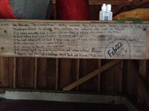
Several of the youngsters, part of the self-styled group, “no parents, no bedtime,” found a challenge written in the shelter. The picture below shows the challenge, though the gist of it was that teams of two had to run BACK DOWN the mountain, hitch into Erwin, order two large pizzas face to face in the pizza shop, buy 24 cans of beer, then run back up the mountain in record time. Bloody crazy, if you ask me, but, incredibly, we soon had another team, from the “7am Crew.” The “vintage” hikers, including me, looked on as these crazy kids, on the stroke of 5pm, hurtled back down the trail.

20140430-170750.jpg

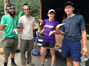
So there we were, ready to eat but not quite sure whether or not there would be pizza in a few hours. Hiker hunger took over, however, so the pots and pans were soon turning out noodles and soups. Amazingly, less than three hours after they left, all four returned with 4 pizzas and 48 cans of beer! It was stupendous and the signal for a party to begin. The teams are below; they are (left to right), Buchanan, True Story, Hawkeye and Science Tooth.

20140430-171235.jpg

I was now planning to meet Diane at Carvers Gap, so had to make sure that I restricted my miles to meet that goal. Accordingly, the next day, I needed to go less than 13 miles, to Cherry Gap Shelter and found myself at lunch on the gorgeous, though somewhat unimaginatively named, Beauty Spot. I tried to turn the view round during the video, so please forgive the dreadful editing!

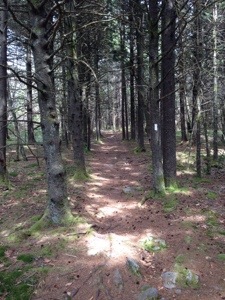
After the splendor of Beauty Spot, I had to struggle up Unaka Mountain, which was quite a treat at the top, with a really beautiful forest of spruce. Note the ubiquitous white blaze in the right foreground; these blazes were particularly necessary in this forest to avoid getting completely lost.

20140430-172033.jpg

We were expecting rain, so I secured a spot in the shelter, amongst the mice and filth, not wishing to pack a wet tent in the morning. No rain came overnight, though there was a lousy forecast for most of the rest of the week. For this reason, I pushed on to Clyde Smith Shelter, only 9 miles away and a pretty easy hike, and I found myself there at about 1.30pm. Most people hiked on, while I settled down on my chair and read my book in the glorious sunshine. The weather started developing quickly, which means that the clouds rushed in, followed by huge rainfall and thunder and lightning. As a consequence, the shelter rapidly filled up and we soon discovered that location is all, as Blue, one of my fragrant tobacco friends, discovered a leak in the roof right above his head. After some rapid temporary repairs, he settled into some semblance of comfort, typically undeterred by this unfortunate turn of events.

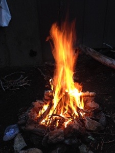
The rain subsided and a Kiwi, named Jandle, set about building the biggest and best bonfire I’ve seen. It was terrific and we were all warmed and buoyed by the fire.

20140430-173000.jpg

Unfortunately, the rain, thunder and lightning returned dramatically and we spent the night battered by the storm. The morning provided what we thought was a temporary break in the weather, and I only had 9 miles to go to meet Diane, but was concerned about my ability to cross Roan High Knob with the impending storm. However, I decided to chance it and the rain happily stayed away for my hike, though it threatened throughout. Sadly, and something of a sign for what was to come later, the clouds descended and I hiked over the last 6,000 ft peak before Mt Washington later this summer in New Hampshire.

This got me to Roan High Knob Shelter for a quick lunch before going the last mile or so to meet Diane at Carver Gap.

Then things got difficult and AT&T let us both down.

I had the dreaded “no service” but hoped to be able to get a signal once on the road. Diane was landing at 12.30, so I hoped we’d meet up around 2.30 or 3pm. However, when I emerged onto Carvers Gap, the visibility was down to about thirty yards and I could hardly see anything, least of all my lovely wife. Nor could I contact her. Once again, I was struck how lost I have become without this lifeline.

Soon after I arrived, a bunch of ladies jumped out of their two cars to hike and offered their Verizon phone for me to try to contact Diane, but I was unable to get through to her and said I’d simply have to stick around until she turned up. Immediately, the goodwill that permeates this Trail came to the fore once more and one of the ladies said she would leave her car unlocked and I could wait inside. I gratefully accepted and sat there, out of the cold until a car drew up.

Hoping it was Diane, I got out quickly, but it turned out to be an elderly couple, who quickly offered to take me down the mountain to try to get a signal or to make a call from the Park office. Ten miles later, still unable to hear from Diane, I had to return to the top, in the cloud, and was run there, kindly, by the same couple. Diane must have turned up there when I left but, after being spooked by the cloud, the mountains, the roads, the lack of any human activity and the fact that I was nowhere to be seen, she made the sensible decision to get to our hotel in the hope I would contact her. Having AT&T, she also had no service at the top.

Eventually, after another hour at the top, a young student and her boyfriend, who had been tracking red squirrels (I mentioned my 50 miles a squirrel record to her great amusement), offered to run me down to Roan Mountain, a nearby town. Ultimately, I got a line and spoke with Diane. She was just too upset to be able to come and get me and I didn’t want to put her through anything else, so I got a lift from a local hostel and got to Boone, NC, at about 8pm.

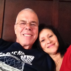
This was a traumatic end to a great day’s hiking, yet you can see from the picture below that we are relaxing today, doing pretty much nothing. Believe me, seeing Diane has revitalized me more than I could have thought and, once she drops me back at Carvers Gap on Friday, I’ll be pushing on more determined than ever to justify her faith in me and my great adventure.

I’m a really lucky guy and I surely know it.

20140430-180003.jpg

Advertisement

Hiking legs

Days 31-35 Hot Springs to Erwin (Mile 342 since Springer Mountain)

Hot Springs was a gorgeous place to spend some time, though I am limiting my zero days as much as possible in order to spend some time with Diane. However, for my young amigos, zero days became double zero days and even triple zero days, as they found the existence of alcohol the very thing to temper the stresses of the Trail.

I headed out on the Monday morning, having twice sampled the delights of Elmer’s vegetarian cooking, at dinner the previous night and breakfast on this Monday morning, and I can highly recommend it. It really was difficult to leave and I turned and took this video as I started my first big climb of the day.

The hiking wasn’t too onerous until I got to Rich Mountain, at about 8 miles, when I really gasped my way up the side of the mountain. I decided to forgo the optional visit up to the fire tower, as it wasn’t on the AT and I don’t intend adding unnecessary mileage to an already full agenda. It wasn’t a clear day, so I rationalized missing out! A precipitous climb down only presaged another lung bursting climb to Spring Mountain Shelter and the exhausting end of an eleven mile day.

The next day was spent hiking in the clouds, with virtually no views to be seen. I had set out to do 15 miles, skipping one shelter for the more distant second one and including a climb that lasted about six and a bit miles and took me from about 2300 ft to Camp Creek Bald at over 4700 ft. This was unrelenting and I had something of a glum day, with nobody around me, nor anything to see. The clouds were all around and I couldn’t see more than about 200 feet in the distance. There was already intermittent rain and I was hopeful that my day was winding down when I encountered Big Firescald Knob (I’m really not making these names up).

With the cloud now closing in, the Trail now chose to let hikers scramble, hand over hand, over huge rocks, such that there were times when I literally had to jump, with my pack on my back, several feet from one rock to the next. To be frank, it was bloody terrifying and I probably took at least 45 minutes to negotiate this little tester. Funnily enough, there was what is referred to as a “blue blaze” alternative to allow hikers not to be exposed to the ridge in bad weather. I thought that cloud could hardly qualify as bad weather, so I set out on the ridge route. I hadn’t hiked more than 50 yards when the heavens opened and I had both the cloud, high winds and now rain to contend with. This was something of a low point in terms of my manliness factor!!

Fortunately, no harm was done and, with 15 miles under my belt, I made it to Jerry Cabin Shelter, at which point, I passed the 300 mile mark.

I had a conversation with my brother, Mike a few miles before this and he related the distance as equivalent to going on vacation as a child, with my brother Dave and my parents. We used to spend an entire day driving across, first, England and then Wales, on quiet roads, and I had hiked pretty much the same distance over mountains. I think we were both awed when we looked at it in that context.

Having lost most of my younger companions, temporarily, to the wonders of alcohol, I now found myself surrounded by a new group of youngsters, more commonly known as stoners. They used to call them potheads in my day, but I think you get my drift. Quite how these guys fit into what I used to call civilization, I really don’t know, but they fit into Trail life perfectly! They find various wild vegetables along the way, cook directly in the campfires, wallow in the filth of the AT and laugh constantly. While I’m aware that this laughter is partly the result of their smoking, I think it is more than that. To a man, they are polite, intelligent, happy and, to be honest, some of the most delightful people I’ve met here. I guess this is another example of something you find out here that you would rarely be exposed to at home; I’m truly blessed to have met them.

Coming out of Jerry Cabin Shelter, with another 15 miler in my sights, I quickly ran into another beautiful spot – a meadow over 4500 ft. These look so out of place, yet they are some of the most arresting sights on the Trail thus far. I had to use my ipad for this video, but it still looks gorgeous, as was the day.

It had been quite an easy decision to go for the 15 miles on this day, as the first shelter I came to was only at 6 miles and I really didn’t want to break my fairly “hot” streak of hiking, so I was happy to see some nice Trail Magic at Devil Fork Gap. A really nice guy was waiting for his wife, Jersey Girl, and regularly meets her with his RV and provides Trail Magic while waiting. We have been really lucky with this phenomenon of the AT and now, entirely unreasonably, seem a little disappointed when we arrive at a road crossing and nobody is there to greet us!

The video below was shot having left Jersey Girl’s husband and you’ll notice that I keep looking at the ground as I hike. This is pretty much a necessity, what with all the stones and tree roots about, so looking at the scenery is secondary to safety, with one false step peremptorily ending hikes for some.

Unfortunately, this calorific intake only lasted for about a couple of miles, and I was soon puffing and panting with another slow chug up Frozen Knob, eventually reaching Hogback Ridge Shelter at about 5pm. Unfortunately, there were virtually no level areas to camp, so I spent my night sliding about in my tent once more as gravity redistributed me and my backpack into the bottom corner of the tent.

I am quite an early riser at camp, often out of bed before others. However, I am dreadfully slow getting everything packed up, coffee made and oatmeal eaten, then everything cleaned and re packed. However, for once, today, this paid off. My usual dilly-dallying had me leaving the shelter slower than all but my stoner friends, but this proved to be the best time to leave as, only about 2.5 miles later, as I descended into Sams Gap, I met two smiling guys, Charlie and Bob, who were putting up a sign to tell hikers of Trail Magic at the gap. They directed me to their wife, Patricia, and I was their first visitor.

Now if there is one thing that most hikers relish, it is pizza. Not only did they have pizza, but it was still in the heating cover. To make it even more of a dream instance of this Trail wonder, they had local beers – on ice! So, there I was, with a couple of my stoner friends, eating hot pepperoni pizza and glugging back beer, in a chair on a gloriously sunny day. They even also had fresh fruit. Happy, happy days.

The day got even better as, apart from the horrendous climb to reach it, I summited the beautiful Big Bald. I showed a video in my last post of Max Patch, another huge expanse of meadow above the trees. This was yet another, with my favorite view thus far and the most glorious weather to see it in. I met up with several people at the top, including my roommate in Hot Springs, Longhorn, along with his companions, Hawkeye, who I’d met on day one at Springer Mountain, Bo and another guy I hadn’t met previously with the mysterious name of Science Tooth. These four had been hiking together and had such a relaxed air that we all just lay out in the grass and nodded off. It was glorious. In all, I spent about an hour and a half at this wonderful place, before settling for a ten mile day at Bald Mountain Shelter only a mile or so further on. Once more, the video doesn’t come close to doing this justice, but just imagine the warmth and the sky and you may get something of a flavor of the place.

It was a cold night in the shelter, not least because it was over 5,000 ft, but I knew that I wanted to try to get into Erwin today and that meant a 17 mile hike. As I’d slept in the shelter, at least I didn’t need to deal with my tent and I got on the Trail at 7.45am.

For some reason I can’t fully explain, I really motored today, spending some time hiking with a great young guy, Little Foot, who is only just turned 18, yet has a confidence far beyond his years. He and his friend, HatTrick, really kept up a strong pace and, for the first time, I was able to match them step for step. I still think that hiking at my own pace is preferable sometimes, but I was certainly helped today. I hope this is evidence that my hikers legs are kicking in, as I’ve put over 340 miles of effort into this and really need to knock out some 20 and 25 mile days in Virginia before slowing again in the north and the dreaded White Mountains.

Still heading north and still hoping to meet with Diane in the coming week.

What makes me happy?

This short post is possible because I have data in the woods for this rare occasion, so I thought I’d relate some of the things that make me happy on the trail.

On several days I have taken completely wrong turns and had to backtrack to where I think I got lost. The trail is marked by white blazes, either on trees or on rocks and, when you’ve been wandering for a while and not seen a blaze, it is extraordinarily reassuring to suddenly spot a blaze up ahead. It is almost an affirmation and the thrill never goes away.

That makes me happy.

Trail magic is another thing that gives me joy and it can come in all types and degrees. The barber in Gatlinburg who shut up shop to run me to the Post Office and then the laundry. Apple, a former thru-hiker, who regularly drives to trail locations for the simple pleasure of providing donuts and coke to thirsty and hungry hikers. Even some of my fellow hikers are unconsciously kind at pretty much all times, offering to help out in any way possible when a fellow traveler needs something.

That makes me happy.

Coming to a shelter at the end of the day, with my knees throbbing, my calves screaming and my feet numb, I immediately enter a company of equals and the easy conversation and friendly cooking begins, before everybody settles down at hiker midnight, which is when the sun goes down.

That makes me happy.

But the thing that makes me happiest of all is when I turn on my phone for the 20th time of the day, expecting to see the hated “no service” yet again, when deep in the woods, only to see that AT&T have granted me the faintest of signals and I’m able to call my Diane. It immediately lifts my mood and I know it makes her happy to hear from me as well. When we can’t speak, I find myself having negative thoughts, yet hearing her voice is all I need to know that all is well and everything is alright in our little world.

While I understand those who prefer the full wilderness experience, absolutely nothing makes me happier than seeing that little lifeline from AT&T.

It’s funny what we find out about ourselves in the woods.

Colden Days

Days 24 – 30 Newfound Gap, Gatlinburg, TN – Hot Springs (Mile 273.9 since Springer Mountain)

It’s been a while since I’ve had access to wifi, but, now I’m in Hot Springs, I can catch up on my adventure so far. As they say, I’ve had good days and I’ve had bad days.

Having watched Bubba win the Masters once more, I still had several errands to complete and I stupidly took my time on Monday, eventually settling for my first zero day (no miles hiked). Gatlinburg is doubtless great if you want to get a tattoo, spend the day at Dollywood, visit Ripley’s Believe It Or Not, or gorge at McDonalds. As I wanted to do none of these, it was pretty much a lousy place to be for me.

My errands involved getting a Post Office pick up from Diane and doing my festering laundry. Realizing that I would have to write the day off for hiking with the weather quickly deteriorating, I decided to renew my Yul Brynner look and found a barber near one of the quaint trolley bus stops. Having to do the laundry meant heading out in a pair of swimming shorts, and using my waterproof jacket as the only things that could survive without a wash. Completing the look were a pair of wet shoes that cost $9 in Walmart. When I tell you that I didn’t look at all out of place in this ensemble, you’ll understand something about Gatlinburg.

Yet another unexpected kindness made my day as, once the local barber had shorn me to within millimeters of my skull, he promptly shut up shop and drove me to not only the post office, but also the laundry. I’d imagine several minutes hovering over me with his clippers made him understand that the laundry was sorely needed and shouldn’t be delayed a moment longer than necessary.

Not wishing the day to be a complete write off and just spend it in my room, I decided to head off to the next town, Pigeon Forge, to watch the new Noah movie, with Russell Crowe. Now I know I’m not entirely familiar with the nuances of the story, but I certainly don’t ever recall the stone monsters, even though they were hugely entertaining; maybe I missed those in Religious Education classes at school. However, I loved the movie and finished off the day with a huge rack of ribs next door before heading back six miles, which inexplicably took three trolley bus rides.

The next day, Tuesday, the weather had worsened considerably and I simply couldn’t stand the thought of spending another day in Gatlinburg, so took the shuttle back out to Newfound Gap to resume my journey. The rain was worsening and, by the time the shuttle had reached the trailhead once more, snow was starting to come down. I was climbing up to over 5,000ft to Pecks Corner Shelter, so had over 10 miles to cover in about 5 hours, with rain, sleet and snow, at varying times battering me on the way. I had been warned that the mountain temperature was likely to drop overnight to the mid teens, and was a little concerned that my 30 degree bag wouldn’t be up to it.

So it proved, as I tried to warm myself by wearing my primary layer and TWO fleece jackets in bed, along with two pairs of socks. It was, by a distance, the worst night of my life, as I worried for my safety. This was exacerbated by the need to pee twice during the night, which entailed leaving the shelter and wandering into a veritable snowstorm and peeing wildly into the night. I confess to performing this operation far too near to the shelter than is required but I’m afraid I wasn’t about to go the requisite 100 yards and then not find my way back. Sue me.

The morning came and, of course, I made it through the night, though I was somewhat chastened by how severe this night had been and saw from the faces of my fellow hikers that I wasn’t the only one who had had concerns. There was a lovely old guy of 77, hiking with his two grandsons, who told us all that he had been in the Arctic Circle a few weeks ago to watch the Northern Lights and that the temperature had been minus 20. He swore that the previous night had felt colder though, to be fair, he had had to get up to pee FOUR times, so perhaps he had a jaundiced view.

His grandsons were 12 and 16 years old and did him and their parents great credit, as they were terrific kids who worked as a team with their grandfather and who were willing to help in every way. It has been impressive to see how well young kids adapt to harsh conditions, both in terms of hiking and weather, as we’ve run into several scouts and they have all been polite, hard working and respectful.

Wednesday greeted all of us with frozen paths, as the snow had stopped and was now making the track treacherous. Of course, I registered yet another fall on the ice, as well as landing hard on my knee another time. It made the hike doubly difficult, as pole placement assumed even greater importance. I had set my sights on Cosby Knob Shelter, nearly 13 miles away, planning to leave myself just over 10 miles to get out of the Smokies the following day at the legendary standing Bear Farm, of which more later.

Both that Wednesday and the following day, I found the path fairly unpleasant, as the ice turned to slush, which in turn turned to muck. I was glad for my boots as my feet stayed warm and dry, but I’m afraid the weather made the second half of the Smokies, for me, much less pleasant than the first half. Starting out on the Tuesday had been an error and I missed many gorgeous views, as everybody who started a day later told me. I goes to show that the views, when and where we get them, should be enjoyed for what they are, when they are and we should all try to stay in the moment. Some of my frustration about this shows in the video, though I’m sure I’ll look back and see them as something of a highlight in time.

Having left the Smokies, I took a couple of quick videos that show me crossing Pigeon River and walking on a pretty track past a stream. The dramatic landscapes that I had been through were now replaced by less drama but equally pretty places, so I thought I’d record them for posterity.

Funnily enough, it was far prettier than it shows in the video, though I think I was just breathing a sigh of relief in this new, gentler landscape.

Standing Bear Farm is apparently a “must go” hostel on the Trail, though, for the life of me, I couldn’t initially understand why. It is located a mile or so from the end of the Smoky Mountains and I had heard it referred to as “rustic.” This could mean anything, particularly to a bunch of smelly hobos, one of which I had undeniably become.

First sight of the place was less than reassuring, with a couple of extras from Deliverance sitting in rocking chairs smiling at me as I entered the establishment. They couldn’t have had more than one full set of teeth between them and when the clearly senior guy, Rocket, introduced himself, I was struck by how he seemed to be a relic of the late 60’s, early 70’s, with his somewhat spaced-out look and laconic delivery. He had apparently been hiking through several years ago, landed at the farm and never really left; I could hear strains of Hotel California in my mind. Later that evening, I asked Rocket how far away the nearest town was and the best he could do was, “We got a gas station ’bout 7 mile thataway an’ I think anudder one ’bout 18 mile tha’ way.” “But where’s the nearest town?” I insisted. After a pause, during which he thoughtfully stroked his chin, he conceded, “Don’ rightly know” as if the thought had never occurred to him.

Despite being geographically challenged, Rocket knew everything about Standing Bear Farm, and he showed every visitor the various buildings that made up the facilities. The bunk room had about 20 beds, some of which were already occupied. Indeed, one guy, Cap’n Guts, comes to the farm for holidays on regular occasions and whiles away the time in this hippy paradise.

Connected to the bunk room was a kind of communal area that had a few threadbare couches for residents to lounge on and generally chew the fat. There was no wifi, as Rocket had converted the building that used to house that (a building for wifi??) into a beer room, with a locked fridge, from which he dispensed cans of beer at $2.50 a time. Very nice. There was a “dining room” that had a sink, table, kind of stove and a pizza oven. Attached at the back of this was the wash room, with a dryer but no washer! There was a washboard and a mangle/ wringer in the sink but, since I had no idea how to use either, I had to forgo the pleasures of clean clothes for a few more days.

The last room was the store, or restock room. There was everything in here, from Snickers to pizza, both of which I bought. This, as opposed to the locked fridge, was offered on the honor system and we had to record what we took then settle with Rocket in the morning.

None of the above should be seen as a complaints against Standing Bear Farm, as it all simply worked. I loved it here! The place was very companionable and everybody had a very chilled time. At $15 for the night, plus purchases, it was a bargain. It shows once more never to judge a book by its cover.

On Friday, hiking away from the farm, I ran into Digger, from Martha’s Vineyard and hiked the whole day with him. He taught me a lot and I really appreciated the day with him. I had been stopping often and grabbing a breath, using my phone to check with the GPS to see where I was. As he said to me, “Why?” The path is still going to be there and the rhythm of the hike is interrupted, so why stop? It was very much because of Digger that I covered over 15 strenuous miles that day, getting to Roaring Fork Shelter having passed over the magnificent Max Patch. I know I’ve over-used the word “awesome” in my videos, but I’m afraid awesome is what it is and I stand by it.

At the shelter, I stayed in my tent for the first time in about 5 days and I was happy to be back in it. Somehow, the privacy enables me to sleep better as I don’t have to worry about others snoring or, probably more correctly, they don’t have to worry about my snoring.

With about 18 miles to go to Hot Springs, I chose to stop short, at Deer Park Mountain Shelter and had something of a frustrating day of hiking, with intermittent rain and the ever-present need to regulate my temperature. I also got lost twice and can assure you that once you have hiked for a while and not seen the white blaze on a tree or a rock, you tend to worry about where you are. Fortunately, these aberrations were quickly resolved and I moved on in the right direction.

As I came to the shelter, I greeted the occupants with “I must have put on and taken off my clothes today more times than a stri……” when i saw a mother and three young children in the shelter. These were the delightful Foxworth family, father Terry, mother Nicole and Morgan, a deliciously innocent tomboy, the enchanting Signe, the fashion diva, and the rambunctious Rion, a very funny and sweet little boy who engaged all in the shelter. A young guy, Cape, and I were sharing the shelter that evening, as the family had two tents to share and we were later joined by another, older guy who’s name escapes me. We were royally entertained by the kids and it was wonderful to be part of a family scene, albeit on the periphery. Once more, I was struck by the benefits of being out in the woods together as a family, if only on this four day trip. It truly was a delight to meet them all.

A quick three miler into town this morning left me at the Smoky Mountain Diner, where calls of “Mighty Blue” rang out when I saw my young friends of about a week ago. A huge breakfast, followed by pulled pork sandwiches this afternoon and I’m shortly to come to grips with a five course vegetarian banquet at Elmer’s this evening where I’m staying.

It has certainly been a mixed week, but one in which I’ve been lucky enough to grow as a hiker and have enjoyed many new and become reacquainted with some “old” friends at the same time.

I’m now only about 70 miles from Erwin, TN, where I hope to be reunited with my lovely wife for a few days. That certainly gives me something to hike for.

It’s all downhill from here

Days 20 – 23 Fontana Dam Shelter to Newfound Gap, Gatlinburg, TN (Mile 206.8 since Springer Mountain)

For those of you who know me, you probably won’t be surprised that I made it to Gatlinburg in time to be showered, fed and glued to the Masters Golf on TV as I write this.

It has been a spectacular three days in the Smokies, elevating not only us but also the quality of our views, so I make no apology of including more videos that can only give you an impression of the views burned on my mind forever.

Fontana Dam was a different experience for us all, with a funny little “town” that appeared to have been constructed for hikers alone.  I had chosen not to stay at the Fontana Dam “Hilton” shelter, though had hiked all the way to it, so I could start my Smoky Mountain experience from the shelter.

The following video shows the unusual view from the shelter that awaited those who spent the night there. Normally, we just see trees and a privy or, if no privy, a toilet paper minefield. Believe me, you really don’t want me to explain that!

The approach to the Great Smoky Mountains National Park, to give it it’s full name, is on the road across the dam itself and I felt a little lonely and very small as I wandered across the dam, with the mighty Smokies fully in my vision. In a way, however, the silence was pretty much in keeping with most mornings, though walking on a flat road was something of a new experience for me.

Our elevation at Fontana Dam was only around 1700ft, while the target for the day, Mollies Ridge Shelter, is at 4570ft, so there was certainly a day of exertion ahead. However, the trail was often wide and I really enjoyed myself.

The next day was yet another milestone, one of particular importance to me, so I’ll let the video explain.

I think we all need goals to achieve and getting under 2000 miles, while still daunting, really makes me feel that I’m progressing toward the ultimate goal, still months away.

On the way, on this gorgeous day, I shot another beautiful short panorama, from Rocky Top, that truly took my breath away. I think you can hear from my hushed voice just how extraordinary the clarity of my view was at that moment.

When I entered the Smokies, I was rather hoping that my wild animal count might take a bit of a boost, as the return thus far had been somewhat underwhelming, with a grand total of 4 squirrels and a deer. FOUR SQUIRRELS, that’s about 40 miles a squirrel!! I see more than that driving through my community in Florida. Several people have suggested that the human corridor that hikers create keeps the animals away, though in one book that I read, Three Hundred Zeroes, by Dennis Blanchard, the author saw 38 bears. I think they’ll have to relocate the AT through several zoos on the way if I’m to see a bear this year!

My haul, now I’m halfway through the Smokies, has increased by just a squirrel and a mouse, so it’s still 40 miles a squirrel! Given the thickness of the woods on this approach trail in the video, you might have thought it would be the perfect hangout for a bear mugging, but all I heard was the odd sound and a few animal cries.

I’ve mentioned some trail magic along the way but forgot to refer to a terrific thing that we experienced in Franklin, NC. A bunch of us were at the Budget Inn when word got around that the First Baptist Church were sending round a couple of buses in the morning to take hikers to breakfast. To be honest, I think it was the unlimited coffee, pancakes and bacon that got most of us up for the 7.15 am bus as opposed to a few well chosen words from the pastor. However, that said, they offered a great breakfast and took pics of each hiker and provided us with notepaper and an envelope to send home to our loved ones. Diane got the letter a couple of days later and was very touched by this simple, but very Christian gesture.

The plan to get to Gatlinburg was very much on target as we left Derrick Knob Shelter on Saturday morning, though I was aware that this was going to be the toughest task. We were going to climb to the highest point on the entire AT, Clingmans Dome, which is at 6643ft. This was a real test for my lungs, though, once more, the views were sensational. I even managed to FaceTime Diane so that she could share the experience when I was near the top.

Clingmans Dome is quite the tourist attraction, so I started to wonder how Cleatus and Leanne would view a bunch of hobos emerging from the woods. I imagined the two of them, in their XXXXXL short shorts, chomping on nachos and cheese, in the haze of their pre-diabetic torpor, as we huffed and puffed towards them. We would be necessarily smug about our efforts, while they would likely use the same word, only taking the “s” at the front of the word and putting it at the end.

However, despite the fact that some of them looked like they had recently ingested a personal banquet, I was pleasantly, and somewhat embarrassingly, surprised by how complimentary and excited everybody we spoke to was about our adventure. I guess it serves me right to have been so cynical in my thoughts. I was at the top of the viewing tower with Boss Man and tried to get a 360 degree view, though you can see we had plenty of company.

They say that the AT provides you with things that you need and I had a prime example of that after Clingmans yesterday. As I approached the Dome, I downed the remainder of my second liter of water of the day, expecting to be able to fill up at Clingmans. Amazingly, there was no water fountain at the top, so I had to hike the remaining 4.5 miles to our overnight shelter with no water. I was getting a little desperate when I remembered that, earlier in the day, a young guy I met at the top of a previous mountain had given me a couple of sweets (candies). These fruity sweets lasted me all the way to camp and kept the dehydration at bay, though I gulped an entire liter when I got there. Funny how things just seem to happen when you’re out here.

This morning, there was a quick 5 miler to Newfound Gap and, aided yet again by the kindness of people, I was able to settle down and watch Bubba win the Masters for the second time.

One last thing that I should mention is that Health and Safety has hit the trail. At our shelter last night, Mt Collins Shelter, a new privy had been installed (yippee) and it is wheelchair accessible. With the best will in the world, a wheelchair could never be used on the trail but not only was there a ramp, but also a handrail against the privy. Makes you wonder, doesn’t it?

Careful planning

Days 17-19 Nantahala Outdoor Center to Fontana Dam Shelter -Mile 165.8 since Springer Mountain

I woke up the following morning in my bunk room, which I was sharing with somebody who had obviously got in later than me, as I hadn’t heard him come in.  When I noticed that he was stirring, I ventured a neighborly, “Morning” to introduce myself.  He grunted morning straight back to me, so we chatted a little before he turned round.  I’d just asked his trail name and, as he moved round in the bunk, he muttered “Blackbeard.”

Never has a trail name been more appropriate.  What greeted me was a perfectly black, bushy beard that made the wearer look as if he’d just eaten a black bear and was just stuffing the rear end into his face.  I must have looked a little startled, but he just smiled and I told him his name worked.

The rain that had been promised was teasing us all, as there was a seven mile hike ahead, with six of those miles taking us from 1,750ft to over 4,200ft.  As the morning progressed, quite a few of my fellow hikers were giving the day up and planning on a zero day, but I received a food package from Diane and thought that the sky looked OK, so I thought I’d chance it.

Typically, when I was only about 10 minutes into the hike and several hundred feet up the mountain, the heavens opened and I had to put on all my waterproof gear and my pack cover.  So much for my weather forecasting skills!

There was nothing more I could do than to press forward, so I stuck at it.  Unfortunately, hiking involves regulation of the body temperature, with removing and adding hats, gloves, jackets and suchlike, though, for me, the toughest thing to do in this regard is when it rains on an uphill slog.

Uphill always makes me sweat, however cold it is outside.  With the rain falling and my waterproof jacket keeping the rain out I find that my sweat continues and I get wetter and ultimately colder on the inside.  When I arrived at Sassafras Gap Shelter that night, I was cold and wet, though I relaxed a little too early and took my second tumble of the trip on the easy walk down into the shelter.

As always, my hiking speed never gIves me the option of a spot in the shelter, so I shuffled off to find the flattest spot left and quickly set up my tent.  I had immediately stripped off my soggy jacket and shirt, both soaking but from opposite directions.  Thus dressed in warmer and dry clothes, I was able to get the tent ready.

A word about the tent.

When I bought it, I hadn’t realized that I’d be sharing it with my pack.  Now, while this simply demonstrates my lack of experience (where, after all, did I think the pack would be spending the night?), it nevertheless gives me a huge problem every night, as I have what amounts to a fight every night simply to put everything in its place.  I can only imagine what it must look like from the outside as I struggle to get out of clothes and into my sleeping bag, all the while shoving things back onto the pack as they topple onto me.  Nightmare!,

Continue reading Careful planning

Confidence

Days 14 – 16 Rock Gap (Franklin, GA) – Nantahala Outdoor Center Mile 137.1 since Springer Mountain

As I had overindulged at the Trail Magic session prior to getting into Franklin the previous night (2 hot dogs, cokes and a comfy chair working their magic on me), I was the sorry sole drop off back at Rock Gap the next day, Friday. Most others had gone on to the traditional Franklin pick up spot, but I’m afraid my greed won me over.

Several of the younger hikers with whom I’d had dinner that evening had decided to stay in town and watch a movie, then have a “nero” day. This they defined as not quite a zero day, meaning no miles hiked at all. Their plan had been to watch the movie, then perhaps catch an early dinner, then hike a few miles to the nearest shelter.

Listening to them discussing the choice of movie was hilarious, as they were debating whether or not to see Noah or The Muppets, hardly contiguous along the spectrum of movies to watch.

Continue reading Confidence

Miles of eating and viewing

Days 10 – 13  Dicks Creek Gap – Rock Gap (Franklin, GA) – Mile 106.1 since Springer Mountain

It has been a few days since my last post but, frankly, getting any sort of signal in the wilderness is a miracle and posting with videos is well nigh impossible.  That said, quite a few miles have passed, so now that I have vaguely usable wifi, I’m going to bring the story up to date.

After my dreadful mistakes the previous day, I was determined to rectify both my eating and drinking input, so I got up fairly early and demolished what the Holiday Inn call their continental breakfast.  In my case, this turned out to be two huge scoops of scrambled egg, a biscuit and about 15 rashers of bacon, followed by two slices of toast, plenty of butter and two dollops of strawberry jam.  I certainly wasn’t going to let hunger get in the way of my admittedly easy day.

By common consent, the previous day had been tough on all of us and, as the shelters are often awkward distances apart, Plumorchard shelter turned out to be the popular choice, with only a five mile hike.

Continue reading Miles of eating and viewing